
Faire un don
Équipez-vous pour votre prochaine aventure :
En tant que Partenaire Amazon, ce site perçoit une commission sur les achats éligibles sans surcoût pour vous.
Carte topographique Forchheim
Cliquez sur la carte pour afficher l’altitude.
Faire un don
Équipez-vous pour votre prochaine aventure :
En tant que Partenaire Amazon, ce site perçoit une commission sur les achats éligibles sans surcoût pour vous.
Forchheim
Forchheim (German pronunciation: [ˈfɔʁçhæɪ̯m] ) is a town in Upper Franconia (German: Oberfranken) in northern Bavaria, and also the seat of the administrative district of Forchheim. Forchheim is a former royal city, and is sometimes called the Gateway to the Franconian Switzerland, referring to the region of outstanding natural beauty to the north east of the town. Nowadays Forchheim is most famous for its ten day long beer and music festival (Annafest) which takes place in late July in an idyllic wooded hillside, home to 24 beer gardens, on the outskirts of the town. Forchheim's population, as of December 2013, was 30,705, and its land area is 44.95 square kilometres (17.36 square miles). Its position is 49° 44' N, 11° 04' E and its elevation is 265 metres (869 feet) above sea level.
Faire un don
Équipez-vous pour votre prochaine aventure :
En tant que Partenaire Amazon, ce site perçoit une commission sur les achats éligibles sans surcoût pour vous.
À propos de cette carte
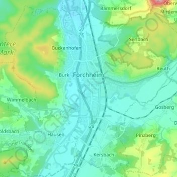
Nom : Carte topographique Forchheim, altitude, relief.
Lieu : Forchheim, Landkreis Forchheim, Bavaria, 91301, Germany (49.67385 10.99958 49.75090 11.12663)
Altitude moyenne : 299 m
Altitude minimum : 250 m
Altitude maximum : 493 m
Faire un don
Équipez-vous pour votre prochaine aventure :
En tant que Partenaire Amazon, ce site perçoit une commission sur les achats éligibles sans surcoût pour vous.
Autres cartes topographiques
Cliquez sur une carte pour visualiser sa topographie, son altitude et son relief.
Faire un don
Équipez-vous pour votre prochaine aventure :
En tant que Partenaire Amazon, ce site perçoit une commission sur les achats éligibles sans surcoût pour vous.
Ebermannstadt
Germany > Bavaria > Landkreis Forchheim > Ebermannstadt > Ebermannstadt
Altitude moyenne : 408 m