
Faire un don
Équipez-vous pour votre prochaine aventure :
En tant que Partenaire Amazon, ce site perçoit une commission sur les achats éligibles sans surcoût pour vous.
Carte topographique Cockermouth
Cliquez sur la carte pour afficher l’altitude.
Faire un don
Équipez-vous pour votre prochaine aventure :
En tant que Partenaire Amazon, ce site perçoit une commission sur les achats éligibles sans surcoût pour vous.
Cockermouth
Cockermouth has a temperate climate that is influenced by the Irish Sea and its low-lying elevation. Cockermouth receives slightly below average rainfall compared with the UK average. Temperatures are also round about average compared with other parts of the UK. The nearest weather station for which online records are available is Aspatria, about 7 miles (11 kilometres) north-northeast of the town centre.
Faire un don
Équipez-vous pour votre prochaine aventure :
En tant que Partenaire Amazon, ce site perçoit une commission sur les achats éligibles sans surcoût pour vous.
À propos de cette carte
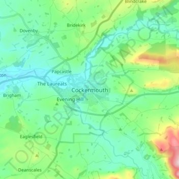
Nom : Carte topographique Cockermouth, altitude, relief.
Altitude moyenne : 105 m
Altitude minimum : 30 m
Altitude maximum : 361 m
Faire un don
Équipez-vous pour votre prochaine aventure :
En tant que Partenaire Amazon, ce site perçoit une commission sur les achats éligibles sans surcoût pour vous.