Carte topographique Hofeck
Carte interactive
Cliquez sur la carte pour afficher l’altitude.
À propos de cette carte
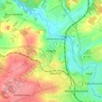
Nom : Carte topographique Hofeck, altitude, relief.
Lieu : Hofeck, Hof, Bayern, 95030, Deutschland (50.31092 11.87450 50.35092 11.91450)
Altitude moyenne : 513 m
Altitude minimum : 463 m
Altitude maximum : 577 m
Autres cartes topographiques
Cliquez sur une carte pour visualiser sa topographie, son altitude et son relief.
Rosenbühl
Deutschland > Bayern > Hof > Osseck
Rosenbühl, Osseck, Hof, Bayern, 95030, Deutschland
Altitude moyenne : 539 m
Hohensaas
Deutschland > Bayern > Hof
Hohensaas, Hof, Bayern, 95030, Deutschland
Altitude moyenne : 544 m
Unterkotzau
Deutschland > Bayern > Hof > Unterkotzau
Unterkotzau, Hof, Bayern, 95030, Deutschland
Altitude moyenne : 509 m
Haidt
Deutschland > Bayern > Hof > Haidt
Haidt, Hof, Bayern, 95028, Deutschland
Altitude moyenne : 527 m
Osseck
Deutschland > Bayern > Hof > Osseck
Osseck, Hof, Bayern, 95030, Deutschland
Altitude moyenne : 551 m
Alsenberg
Deutschland > Bayern > Hof > Alsenberg
Alsenberg, Hof, Bayern, 95028, Deutschland
Altitude moyenne : 510 m