
Carte topographique Silay
Cliquez sur la carte pour afficher l’altitude.
À propos de cette carte
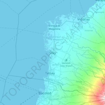
Nom : Carte topographique Silay, altitude, relief.
Altitude moyenne : 44 m
Altitude minimum : -1 m
Altitude maximum : 704 m
Autres cartes topographiques
Cliquez sur une carte pour visualiser sa topographie, son altitude et son relief.
Cauayan
Philippines > Negros Occidental
The municipality of Cauayan has a rugged topography. Mt. Malipantao, considered the highest peak in the province, separates the municipality from the town of Candoni and the city of Sipalay. Portion of the ranges are the remaining thick forest that needs protection where the watershed is located. The remaining…
Altitude moyenne : 93 m
Don Salvador Benedicto
Philippines > Negros Occidental
Although a small town, the town of Don Salvador Benedicto has seen a rise in its municipal economy thanks to tourism and local agriculture. Due to its high altitude like Baguio, the town can support crops that grow in temperate areas, making it ideal for a multitude of farming businesses. Tourism is on the…
Altitude moyenne : 710 m
Mount Kanlaon Natural Park
Philippines > Negros Occidental > San Carlos
Kanlaon, also known as Mount Kanlaon and Kanlaon Volcano (Hiligaynon: Bolkang Kanglaon; Cebuano: Bolkang Kanglaon; Filipino: Bulkang Kanlaon), is an active stratovolcano and the highest mountain on the island of Negros in the Philippines, as well as the highest point in the Visayas, with an elevation of 2,465…
Altitude moyenne : 650 m
Himamaylan City Public Plaza
Philippines > Negros Occidental > Himamaylan > Barangay Ⅲ
Altitude moyenne : 5 m
Don Salvador Benedicto
Philippines > Negros Occidental
Although a small town, the town of Don Salvador Benedicto has seen a rise in its municipal economy thanks to tourism and local agriculture. Due to its high altitude like Baguio, the town can support crops that grow in temperate areas, making it ideal for a multitude of farming businesses. Tourism is on the…
Altitude moyenne : 710 m