
Faire un don
Équipez-vous pour votre prochaine aventure :
En tant que Partenaire Amazon, ce site perçoit une commission sur les achats éligibles sans surcoût pour vous.
Carte topographique Blanca Peak
Cliquez sur la carte pour afficher l’altitude.
Faire un don
Équipez-vous pour votre prochaine aventure :
En tant que Partenaire Amazon, ce site perçoit une commission sur les achats éligibles sans surcoût pour vous.
Blanca Peak
Blanca Peak is notable not only for its absolute height, but also for its great local relief and dominant position at the end of the range, rising high above the San Luis Valley to the west. For example, it rises nearly 7,000 feet (2,100 m) over the edge of the San Luis Valley in only 6 miles (9.7 km). Blanca is also the third most topographically prominent peak in Colorado; it is separated from the higher peaks in the Sawatch Range by relatively low Poncha Pass at 9,019 feet (2,749 m).
Faire un don
Équipez-vous pour votre prochaine aventure :
En tant que Partenaire Amazon, ce site perçoit une commission sur les achats éligibles sans surcoût pour vous.
À propos de cette carte
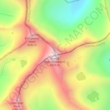
Nom : Carte topographique Blanca Peak, altitude, relief.
Lieu : Blanca Peak, Alamosa County, Colorado, United States (37.57748 -105.48572 37.57758 -105.48562)
Altitude moyenne : 3.870 m
Altitude minimum : 3.347 m
Altitude maximum : 4.363 m
Faire un don
Équipez-vous pour votre prochaine aventure :
En tant que Partenaire Amazon, ce site perçoit une commission sur les achats éligibles sans surcoût pour vous.
Autres cartes topographiques
Cliquez sur une carte pour visualiser sa topographie, son altitude et son relief.
Alamosa
United States > Colorado > Alamosa County
Alamosa is located along the Rio Grande in the San Luis Valley, in the highest general agricultural land in the United States. Elevation is about 7,544 feet (2,299 m) in Alamosa with peaks over 14,000 feet (4,300 m) within 23 miles (37 km) of town in the Sangre de Cristo Range.
Altitude moyenne : 2.300 m
Faire un don
Équipez-vous pour votre prochaine aventure :
En tant que Partenaire Amazon, ce site perçoit une commission sur les achats éligibles sans surcoût pour vous.