
Carte topographique Jamindan
Cliquez sur la carte pour afficher l’altitude.
À propos de cette carte
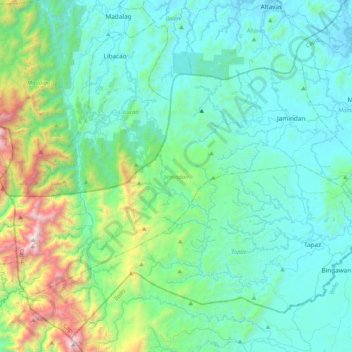
Nom : Carte topographique Jamindan, altitude, relief.
Lieu : Jamindan, Capiz, Western Visayas, 5808, Philippines (11.20008 122.17740 11.48181 122.59306)
Altitude moyenne : 149 m
Altitude minimum : -2 m
Altitude maximum : 1.139 m
Autres cartes topographiques
Cliquez sur une carte pour visualiser sa topographie, son altitude et son relief.
Mount Nangtud
Philippines > Capiz > Jamindan
Mount Nangtud is the second highest peak on the island of Panay, in the Philippines and third highest mountain in the Visayas, after Mount Kanlaon and Mount Madja-as. With an elevation of 2,074 m (6,804 ft) above sea level, it is located geographically within Jamindan, Capiz bordering with Barbaza, Antique.…
Altitude moyenne : 1.578 m