
Faire un don
Équipez-vous pour votre prochaine aventure :
En tant que Partenaire Amazon, ce site perçoit une commission sur les achats éligibles sans surcoût pour vous.
Carte topographique Clarksburg
Cliquez sur la carte pour afficher l’altitude.
Faire un don
Équipez-vous pour votre prochaine aventure :
En tant que Partenaire Amazon, ce site perçoit une commission sur les achats éligibles sans surcoût pour vous.
Clarksburg
Clarksburg had a humid continental climate if one considers the 0 °C isotherm. The latest temperature numbers have the climate as humid subtropical (Cfa). To the molds of Köppen the climate may be considered the southern boundary of the Dfb zone at low altitudes in the North American continent (limit of 39 ° N), although in the immediate vicinity it is Dfa. The city still suffers strong influences from the south, especially from the Gulf of Mexico but due to its location has a much more significant influence of the cold air intrusion of Canada, where it is not protected by the Appalachians. The extent further to the south is due to the eastern and southeastern mountain ranges blocking the oceanic influence in part, even if it is minimal anyway by the considerable distance from the coast. At the same time it can be classified as Cfa or hybrid of different climatic zones according to the criterion to be surveyed, a situation similar to that of Boston. It is the Dfb boundary throughout the northern hemisphere if it is to be disregarded in elevated regions on all continents. The southern record could appear on the Korean peninsula but the dry season defined version (Dwb) predominates in these locations. The average temperature is 52.2 °F (11.2 °C) with a high average of 63.3 °F (17.4 °C) and a low average of 41.1 °F (5.1 °C). It has 45.6 inches (1,160 mm) of rain with peak in May (4.8 inches or 122 mm) and lower value in February with 3.2 inches (81 mm). The amount of total snow is 25 inches (64 cm), with highest values between January and February, 8 inches (20 cm) in total for each month. Since the season of snowfall goes from November to March.
Faire un don
Équipez-vous pour votre prochaine aventure :
En tant que Partenaire Amazon, ce site perçoit une commission sur les achats éligibles sans surcoût pour vous.
À propos de cette carte
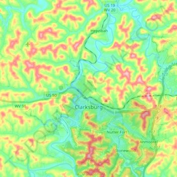
Nom : Carte topographique Clarksburg, altitude, relief.
Lieu : Clarksburg, Harrison County, West Virginia, United States (39.24993 -80.40078 39.33619 -80.24495)
Altitude moyenne : 347 m
Altitude minimum : 275 m
Altitude maximum : 475 m
Faire un don
Équipez-vous pour votre prochaine aventure :
En tant que Partenaire Amazon, ce site perçoit une commission sur les achats éligibles sans surcoût pour vous.
Autres cartes topographiques
Cliquez sur une carte pour visualiser sa topographie, son altitude et son relief.
Faire un don
Équipez-vous pour votre prochaine aventure :
En tant que Partenaire Amazon, ce site perçoit une commission sur les achats éligibles sans surcoût pour vous.
Clarksburg City Park
United States > West Virginia > Harrison County > Nutter Fort
Altitude moyenne : 335 m
Faire un don
Équipez-vous pour votre prochaine aventure :
En tant que Partenaire Amazon, ce site perçoit une commission sur les achats éligibles sans surcoût pour vous.