
Faire un don
Équipez-vous pour votre prochaine aventure :
En tant que Partenaire Amazon, ce site perçoit une commission sur les achats éligibles sans surcoût pour vous.
Carte topographique Lusaka Province
Cliquez sur la carte pour afficher l’altitude.
Faire un don
Équipez-vous pour votre prochaine aventure :
En tant que Partenaire Amazon, ce site perçoit une commission sur les achats éligibles sans surcoût pour vous.
Lusaka Province
Lusaka Province is bordered along Zimbabwe along Lower Zambezi National Park in the south, Central Province in the north, Southern Province in the southwest and Eastern Province in the north east. The general topography of the province is characterized by uplifted planation surfaces. The general elevation of the nation as a whole is tended towards West to East from the Kalahari Basin. The level of land falls from the upper Congo towards the Zambezi depression in the South forming a plateau.
Faire un don
Équipez-vous pour votre prochaine aventure :
En tant que Partenaire Amazon, ce site perçoit une commission sur les achats éligibles sans surcoût pour vous.
À propos de cette carte
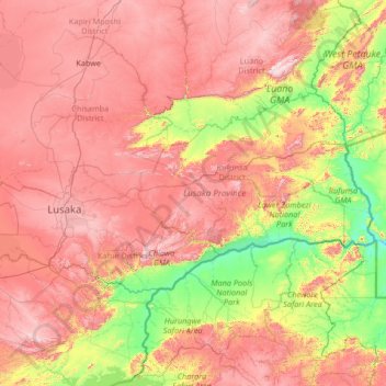
Nom : Carte topographique Lusaka Province, altitude, relief.
Lieu : Lusaka Province, Zambia (-15.97010 27.76911 -14.64314 30.42080)
Altitude moyenne : 866 m
Altitude minimum : 325 m
Altitude maximum : 1.604 m
Faire un don
Équipez-vous pour votre prochaine aventure :
En tant que Partenaire Amazon, ce site perçoit une commission sur les achats éligibles sans surcoût pour vous.
Autres cartes topographiques
Cliquez sur une carte pour visualiser sa topographie, son altitude et son relief.
Faire un don
Équipez-vous pour votre prochaine aventure :
En tant que Partenaire Amazon, ce site perçoit une commission sur les achats éligibles sans surcoût pour vous.
Faire un don
Équipez-vous pour votre prochaine aventure :
En tant que Partenaire Amazon, ce site perçoit une commission sur les achats éligibles sans surcoût pour vous.
Faire un don
Équipez-vous pour votre prochaine aventure :
En tant que Partenaire Amazon, ce site perçoit une commission sur les achats éligibles sans surcoût pour vous.
Faire un don
Équipez-vous pour votre prochaine aventure :
En tant que Partenaire Amazon, ce site perçoit une commission sur les achats éligibles sans surcoût pour vous.
Chipata
Chipata is located on the Great East Road, approximately 570 kilometres (354 mi) east of Lusaka, the capital city of Zambia. This is about 150 kilometres (93 mi) west of Lilongwe, the capital city of Malawi. The geographical coordinates of Chipata are 13°38′43.0″S, 32°38′47.0″E. The average elevation…
Altitude moyenne : 1.133 m
Faire un don
Équipez-vous pour votre prochaine aventure :
En tant que Partenaire Amazon, ce site perçoit une commission sur les achats éligibles sans surcoût pour vous.