
Carte topographique Ely
Carte interactive
Cliquez sur la carte pour afficher l’altitude.
À propos de cette carte
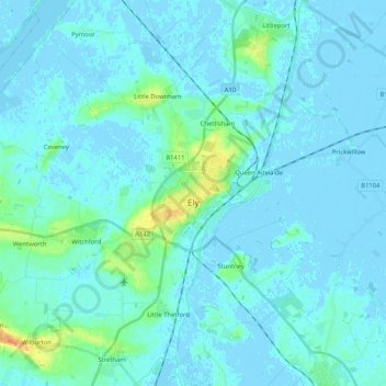
Nom : Carte topographique Ely, altitude, relief.
Altitude moyenne : 4 m
Altitude minimum : -5 m
Altitude maximum : 36 m
Ely is built on a 23-square-mile (60 km2) Kimmeridge Clay island which, at 85 feet (26 m), is the highest land in the Fens. It was due to this topography that Ely was not waterlogged like the surrounding Fenland, and was an island separated from the mainland. Major rivers including the Witham, Welland, Nene and Great Ouse feed into the Fens and, until draining commenced in the eighteenth century, formed freshwater marshes and meres within which peat was laid down. Once the Fens were drained, this peat created a rich and fertile soil ideal for farming.
Autres cartes topographiques
Cliquez sur une carte pour visualiser sa topographie, son altitude et son relief.
South Cambridgeshire
United Kingdom > England > Cambridgeshire
South Cambridgeshire, Cambridgeshire, Cambridgeshire and Peterborough, England, United Kingdom
Altitude moyenne : 42 m
March
United Kingdom > England > Cambridgeshire > Fenland District
March, Fenland District, Cambridgeshire, Cambridgeshire and Peterborough, England, United Kingdom
Altitude moyenne : 1 m
Chatteris
United Kingdom > England > Cambridgeshire > Fenland District
Chatteris, Fenland District, Cambridgeshire, Cambridgeshire and Peterborough, England, United Kingdom
Altitude moyenne : 2 m
Whittlesey
United Kingdom > England > Cambridgeshire > Fenland District
Whittlesey, Fenland District, Cambridgeshire, Cambridgeshire and Peterborough, England, United Kingdom
Altitude moyenne : 1 m
Waterbeach
United Kingdom > England > Cambridgeshire > South Cambridgeshire
Waterbeach, South Cambridgeshire, Cambridgeshire, Cambridgeshire and Peterborough, England, United Kingdom
Altitude moyenne : 4 m
Haddenham
United Kingdom > England > Cambridgeshire > East Cambridgeshire
Haddenham, East Cambridgeshire, Cambridgeshire, Cambridgeshire and Peterborough, England, United Kingdom
Altitude moyenne : 7 m
Cambridge
United Kingdom > England > Cambridgeshire > Cambridge
Cambridge, Cambridgeshire, East of England, England, CB2 3NR, United Kingdom
Altitude moyenne : 33 m
Reach
United Kingdom > England > Cambridgeshire > East Cambridgeshire
Reach, East Cambridgeshire, Cambridgeshire, Cambridgeshire and Peterborough, England, United Kingdom
Altitude moyenne : 5 m
Cambridge
United Kingdom > England > Cambridgeshire
Cambridge, Cambridgeshire, Cambridgeshire and Peterborough, England, United Kingdom
Altitude moyenne : 18 m
Huntingdon
United Kingdom > England > Cambridgeshire > Huntingdonshire
Huntingdon, Godmanchester, Huntingdonshire, Cambridgeshire, Cambridgeshire and Peterborough, England, United Kingdom
Altitude moyenne : 25 m
Old Weston
United Kingdom > England > Cambridgeshire > Huntingdonshire
Old Weston, Huntingdonshire, Cambridgeshire, East of England, England, United Kingdom
Altitude moyenne : 65 m
Orwell
United Kingdom > England > Cambridgeshire > South Cambridgeshire
Orwell, South Cambridgeshire, Cambridgeshire, Cambridgeshire and Peterborough, England, United Kingdom
Altitude moyenne : 34 m
Godmanchester
United Kingdom > England > Cambridgeshire > Huntingdonshire > Godmanchester
Godmanchester, Huntingdonshire, Cambridgeshire, East of England, England, United Kingdom
Altitude moyenne : 22 m