
Carte topographique Farg Qaleh
Carte interactive
Cliquez sur la carte pour afficher l’altitude.
À propos de cette carte
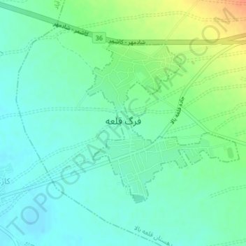
Nom : Carte topographique Farg Qaleh, altitude, relief.
Lieu : Farg Qaleh, بخش فرح دشت, Kashmar County, Razavi Khorasan, Iran (35.21298 58.55166 35.23045 58.57218)
Altitude moyenne : 1.082 m
Altitude minimum : 1.069 m
Altitude maximum : 1.110 m
Autres cartes topographiques
Cliquez sur une carte pour visualiser sa topographie, son altitude et son relief.
Kashmar
Iran > Razavi Khorasan > Kashmar County > Kashmar
Kashmar, بخش مرکزی کاشمر, Kashmar County, Razavi Khorasan, Iran
Altitude moyenne : 1.084 m