
Faire un don
Équipez-vous pour votre prochaine aventure :
En tant que Partenaire Amazon, ce site perçoit une commission sur les achats éligibles sans surcoût pour vous.
Carte topographique Matjhabeng Local Municipality
Cliquez sur la carte pour afficher l’altitude.
Faire un don
Équipez-vous pour votre prochaine aventure :
En tant que Partenaire Amazon, ce site perçoit une commission sur les achats éligibles sans surcoût pour vous.
À propos de cette carte
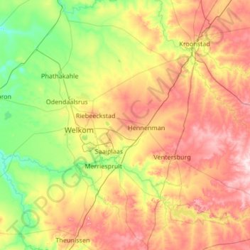
Nom : Carte topographique Matjhabeng Local Municipality, altitude, relief.
Altitude moyenne : 1.376 m
Altitude minimum : 1.257 m
Altitude maximum : 1.579 m
Faire un don
Équipez-vous pour votre prochaine aventure :
En tant que Partenaire Amazon, ce site perçoit une commission sur les achats éligibles sans surcoût pour vous.
Autres cartes topographiques
Cliquez sur une carte pour visualiser sa topographie, son altitude et son relief.
Bothaville
South Africa > Free State > Lejweleputswa District Municipality > Nala Local Municipality
Altitude moyenne : 1.287 m
Welkom
South Africa > Free State > Lejweleputswa District Municipality
Koppie Alleen is the only hill near Welkom and therefore is aptly named for its oddity. The terrain elevation above sea level is 1435 metres. The largest water catchment is the Sand River to the south-east of Welkom in Virginia's direction. Large saline pans such as Flamingo Pan and Theronia Pan are situated…
Altitude moyenne : 1.341 m
Hoopstad
South Africa > Free State > Lejweleputswa District Municipality > Tswelopele Local Municipality
Altitude moyenne : 1.251 m
Bultfontein
South Africa > Free State > Lejweleputswa District Municipality > Tswelopele Local Municipality
Altitude moyenne : 1.326 m
Faire un don
Équipez-vous pour votre prochaine aventure :
En tant que Partenaire Amazon, ce site perçoit une commission sur les achats éligibles sans surcoût pour vous.
Harmony
South Africa > Free State > Lejweleputswa District Municipality > Matjhabeng Local Municipality
Altitude moyenne : 1.333 m
Winnie Mandela (Brandfort)
South Africa > Free State > Lejweleputswa District Municipality > Masilonyana Local Municipality
Altitude moyenne : 1.403 m
Virginia
South Africa > Free State > Lejweleputswa District Municipality > Matjhabeng Local Municipality
Altitude moyenne : 1.326 m
Theunissen
South Africa > Free State > Lejweleputswa District Municipality > Masilonyana Local Municipality
Altitude moyenne : 1.395 m
Faire un don
Équipez-vous pour votre prochaine aventure :
En tant que Partenaire Amazon, ce site perçoit une commission sur les achats éligibles sans surcoût pour vous.
Odendaalsrus
South Africa > Free State > Lejweleputswa District Municipality > Matjhabeng Local Municipality
Altitude moyenne : 1.336 m
Hertzogville
South Africa > Free State > Lejweleputswa District Municipality > Tokologo Local Municipality
Altitude moyenne : 1.285 m
Wesselsbron
South Africa > Free State > Lejweleputswa District Municipality > Nala Local Municipality
Altitude moyenne : 1.297 m
Verkeerdevlei
South Africa > Free State > Lejweleputswa District Municipality > Masilonyana Local Municipality
Altitude moyenne : 1.474 m
Faire un don
Équipez-vous pour votre prochaine aventure :
En tant que Partenaire Amazon, ce site perçoit une commission sur les achats éligibles sans surcoût pour vous.
Bloemhof Dam
South Africa > Free State > Lejweleputswa District Municipality > Tswelopele Local Municipality
Altitude moyenne : 1.228 m
HJ Joel Nature Reserve
South Africa > Free State > Lejweleputswa District Municipality > Masilonyana Local Municipality
Altitude moyenne : 1.386 m
Erfenis Dam
South Africa > Free State > Lejweleputswa District Municipality > Masilonyana Local Municipality
Altitude moyenne : 1.356 m
Welkom
South Africa > Free State > Lejweleputswa District Municipality
Koppie Alleen is the only hill near Welkom and therefore is aptly named for its oddity. The terrain elevation above sea level is 1435 metres. The largest water catchment is the Sand River to the south-east of Welkom in Virginia's direction. Large saline pans such as Flamingo Pan and Theronia Pan are situated…
Altitude moyenne : 1.341 m
Faire un don
Équipez-vous pour votre prochaine aventure :
En tant que Partenaire Amazon, ce site perçoit une commission sur les achats éligibles sans surcoût pour vous.
Bothaville
South Africa > Free State > Lejweleputswa District Municipality > Nala Local Municipality
Altitude moyenne : 1.287 m
Bronville
South Africa > Free State > Lejweleputswa District Municipality > Matjhabeng Local Municipality
Altitude moyenne : 1.365 m
Welkom
South Africa > Free State > Lejweleputswa District Municipality
Koppie Alleen is the only hill near Welkom and therefore is aptly named for its oddity. The terrain elevation above sea level is 1435 metres. The largest water catchment is the Sand River to the south-east of Welkom in Virginia's direction. Large saline pans such as Flamingo Pan and Theronia Pan are situated…
Altitude moyenne : 1.341 m
Faire un don
Équipez-vous pour votre prochaine aventure :
En tant que Partenaire Amazon, ce site perçoit une commission sur les achats éligibles sans surcoût pour vous.
Bothaville
South Africa > Free State > Lejweleputswa District Municipality > Nala Local Municipality
Altitude moyenne : 1.287 m
Highveld
South Africa > Free State > Lejweleputswa District Municipality > Matjhabeng Local Municipality
The Highveld (Afrikaans: Hoëveld, pronounced [ˈɦuəfælt], lit. 'High Field') is the portion of the South African inland plateau which has an altitude above roughly 1,500 m (4,900 ft), but below 2,100 m (6,900 ft), thus excluding the Lesotho mountain regions to the south-east of the Highveld. It is home…
Altitude moyenne : 1.380 m
Odendaalsrus
South Africa > Free State > Lejweleputswa District Municipality > Matjhabeng Local Municipality
Altitude moyenne : 1.336 m
Allanridge
South Africa > Free State > Lejweleputswa District Municipality > Matjhabeng Local Municipality
Altitude moyenne : 1.311 m
Faire un don
Équipez-vous pour votre prochaine aventure :
En tant que Partenaire Amazon, ce site perçoit une commission sur les achats éligibles sans surcoût pour vous.
Highveld
South Africa > Free State > Lejweleputswa District Municipality > Matjhabeng Local Municipality
Altitude moyenne : 1.380 m
Bothaville
South Africa > Free State > Lejweleputswa District Municipality > Nala Local Municipality
Altitude moyenne : 1.287 m
Boshof
South Africa > Free State > Lejweleputswa District Municipality > Tokologo Local Municipality
Altitude moyenne : 1.252 m
Riebeeckstad
South Africa > Free State > Lejweleputswa District Municipality > Matjhabeng Local Municipality
Altitude moyenne : 1.384 m
Faire un don
Équipez-vous pour votre prochaine aventure :
En tant que Partenaire Amazon, ce site perçoit une commission sur les achats éligibles sans surcoût pour vous.
Bultfontein
South Africa > Free State > Lejweleputswa District Municipality > Tswelopele Local Municipality
Altitude moyenne : 1.326 m
Brandfort
South Africa > Free State > Lejweleputswa District Municipality > Masilonyana Local Municipality
Altitude moyenne : 1.403 m
Ventersburg
South Africa > Free State > Lejweleputswa District Municipality > Matjhabeng Local Municipality
Altitude moyenne : 1.438 m
Winnie Mandela (Brandfort)
South Africa > Free State > Lejweleputswa District Municipality > Masilonyana Local Municipality
Altitude moyenne : 1.403 m
Faire un don
Équipez-vous pour votre prochaine aventure :
En tant que Partenaire Amazon, ce site perçoit une commission sur les achats éligibles sans surcoût pour vous.
Virginia
South Africa > Free State > Lejweleputswa District Municipality > Matjhabeng Local Municipality > Virginia
Altitude moyenne : 1.326 m
Winburg
South Africa > Free State > Lejweleputswa District Municipality > Masilonyana Local Municipality
Altitude moyenne : 1.449 m