
Faire un don
Équipez-vous pour votre prochaine aventure :
En tant que Partenaire Amazon, ce site perçoit une commission sur les achats éligibles sans surcoût pour vous.
Carte topographique Tseax Cone
Cliquez sur la carte pour afficher l’altitude.
Faire un don
Équipez-vous pour votre prochaine aventure :
En tant que Partenaire Amazon, ce site perçoit une commission sur les achats éligibles sans surcoût pour vous.
Tseax Cone
Tseax Cone (/ˈsiːæks/ SEE-aks) is a small volcano in the Nass Ranges of the Hazelton Mountains in northwestern British Columbia, Canada. It has an elevation of 609 metres (1,998 feet) and lies within an east–west valley through which a tributary of the Tseax River flows. The volcano consists of two nested structures and was the source of four lava flows that descended into neighbouring valleys. A secondary eruptive centre lies just north of Tseax Cone on the opposite side of Melita Lake. It probably formed simultaneously with Tseax Cone, but the timing of volcanism at the two eruptive centres is not precisely known; both were formed by volcanic activity sometime in the last 800 years.
Faire un don
Équipez-vous pour votre prochaine aventure :
En tant que Partenaire Amazon, ce site perçoit une commission sur les achats éligibles sans surcoût pour vous.
À propos de cette carte
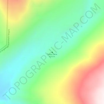
Nom : Carte topographique Tseax Cone, altitude, relief.
Altitude moyenne : 723 m
Altitude minimum : 434 m
Altitude maximum : 1.210 m
Faire un don
Équipez-vous pour votre prochaine aventure :
En tant que Partenaire Amazon, ce site perçoit une commission sur les achats éligibles sans surcoût pour vous.
Autres cartes topographiques
Cliquez sur une carte pour visualiser sa topographie, son altitude et son relief.
Munro Lake
Canada > British Columbia > Regional District of Kitimat-Stikine > Area A (Nass Valley/Bell Irving)
Altitude moyenne : 707 m
Tom Mackay Lake
Canada > British Columbia > Regional District of Kitimat-Stikine > Area A (Nass Valley/Bell Irving)
Altitude moyenne : 1.138 m
Border Lake Provincial Park
Canada > British Columbia > Regional District of Kitimat-Stikine > Area A (Nass Valley/Bell Irving)
Altitude moyenne : 308 m
Sandal Lake
Canada > British Columbia > Regional District of Kitimat-Stikine > Area A (Nass Valley/Bell Irving)
Altitude moyenne : 379 m
Faire un don
Équipez-vous pour votre prochaine aventure :
En tant que Partenaire Amazon, ce site perçoit une commission sur les achats éligibles sans surcoût pour vous.
Derrick Lake
Canada > British Columbia > Regional District of Kitimat-Stikine > Area A (Nass Valley/Bell Irving)
Altitude moyenne : 476 m