
Carte topographique Melville
Carte interactive
Cliquez sur la carte pour afficher l’altitude.
À propos de cette carte
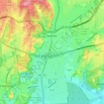
Nom : Carte topographique Melville, altitude, relief.
Altitude moyenne : 53 m
Altitude minimum : 18 m
Altitude maximum : 113 m
Long Island's highest point is Jayne's Hill in the neighboring hamlet of West Hills, with an elevation of 387 feet (118 m) to 400.9 feet (122.2 m) above sea level.
Autres cartes topographiques
Cliquez sur une carte pour visualiser sa topographie, son altitude et son relief.
East Northport
United States > New York > Suffolk County > Town of Huntington
East Northport, Town of Huntington, Suffolk County, New York, 11731, United States
Altitude moyenne : 54 m
Commack
United States > New York > Suffolk County > Town of Huntington
Commack, Town of Huntington, Suffolk County, New York, 11725, United States
Altitude moyenne : 51 m
Eatons Neck
United States > New York > Suffolk County > Town of Huntington
Eatons Neck, Town of Huntington, Suffolk County, New York, United States
Altitude moyenne : 5 m
Village of Lloyd Harbor
United States > New York > Suffolk County > Town of Huntington
Village of Lloyd Harbor, Town of Huntington, Suffolk County, New York, United States
Altitude moyenne : 14 m
Huntington Station
United States > New York > Suffolk County > Town of Huntington
Huntington Station, Town of Huntington, Suffolk County, New York, United States
Altitude moyenne : 60 m