Carte topographique Cuxton
Carte interactive
Cliquez sur la carte pour afficher l’altitude.
À propos de cette carte
![Carte topographique Cuxton, altitude, relief](/pub/maps/relation/8fm2/f9p8f3/thumbnail.jpg)
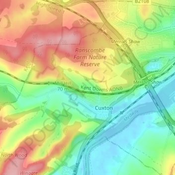
Nom : Carte topographique Cuxton, altitude, relief.
Lieu : Cuxton, Medway, England, United Kingdom (51.36463 0.41401 51.39429 0.47569)
Altitude moyenne : 57 m
Altitude minimum : -6 m
Altitude maximum : 131 m
Autres cartes topographiques
Cliquez sur une carte pour visualiser sa topographie, son altitude et son relief.
![Carte topographique Borstal, altitude, relief](/pub/maps/node/4ktp/v8jzj51/icon.jpg)
Borstal
United Kingdom > England > Medway > Rochester
Borstal, Rochester, Medway, England, ME1 3HX, United Kingdom
Altitude moyenne : 44 m
![Carte topographique Cliffe, altitude, relief](/pub/maps/node/4dnh/9zpr45k/icon.jpg)
Cliffe
United Kingdom > England > Medway
Cliffe, Medway, England, ME3 7RH, United Kingdom
Altitude moyenne : 5 m
![Carte topographique Salters Cross, altitude, relief](/pub/maps/node/fdnh/wx7gjmnx/icon.jpg)
Salters Cross
United Kingdom > England > Medway > Strood
Salters Cross, Strood, Medway, England, ME2 2LY, United Kingdom
Altitude moyenne : 55 m
![Carte topographique Chatham, altitude, relief](/pub/maps/node/7ls8/q8kpm2/icon.jpg)
Chatham
United Kingdom > England > Medway
Chatham, Medway, England, ME4 4AP, United Kingdom
Altitude moyenne : 49 m
![Carte topographique Chatham, altitude, relief](/pub/maps/relation/8pdn/qdd14/icon.jpg)
Chatham
United Kingdom > England > Medway
Chatham, Medway, England, United Kingdom
Altitude moyenne : 70 m
![Carte topographique Broad Street, altitude, relief](/pub/maps/node/61f3/czv68t6/icon.jpg)
Broad Street
United Kingdom > England > Medway > Lower Upnor
Broad Street, Hoo St. Werburgh, Lower Upnor, Hoo St Werburgh, Medway, England, ME3 9HG, United Kingdom
Altitude moyenne : 25 m
![Carte topographique Upper Halling, altitude, relief](/pub/maps/node/dpnh/bqkdzb3/icon.jpg)
Upper Halling
United Kingdom > England > Medway
Upper Halling, Medway, England, ME2 1JD, United Kingdom
Altitude moyenne : 62 m
![Carte topographique Silver Street, altitude, relief](/pub/maps/node/xjkl/qj26rtf/icon.jpg)
Silver Street
United Kingdom > England > Medway > Wainscott
Silver Street, Frindsbury Extra, Wainscott, Frindsbury, Medway, England, ME3 8BN, United Kingdom
Altitude moyenne : 29 m
![Carte topographique Gillingham, altitude, relief](/pub/maps/relation/lhzs/x6c51/icon.jpg)
Gillingham
United Kingdom > England > Medway
Gillingham, Medway, England, United Kingdom
Altitude moyenne : 59 m
![Carte topographique Damhead Creek, altitude, relief](/pub/maps/way/6wgt/sr3wl6b3/icon.jpg)
Damhead Creek
United Kingdom > England > Medway > Kingsnorth
Damhead Creek, Hoo St. Werburgh, Kingsnorth, Medway, England, ME3 9GX, United Kingdom
Altitude moyenne : 4 m
![Carte topographique Lee Green, altitude, relief](/pub/maps/node/5r57/flkn751/icon.jpg)
Lee Green
United Kingdom > England > Medway > Frindsbury
Lee Green, Frindsbury Extra, Frindsbury, Medway, England, ME3 8EX, United Kingdom
Altitude moyenne : 27 m
![Carte topographique Fort Borstal, altitude, relief](/pub/maps/way/mzcz/5vhc1nx/icon.jpg)
Fort Borstal
United Kingdom > England > Medway > Rochester > Borstal
Fort Borstal, St Johns Way, Troy Town, Borstal, Rochester, Medway, England, ME1 3NG, United Kingdom
Altitude moyenne : 50 m
![Carte topographique Farthing Corner, altitude, relief](/pub/maps/node/jmnx/ssxpqrr/icon.jpg)
Farthing Corner
United Kingdom > England > Medway > Gillingham
Farthing Corner, Rainham, Gillingham, Medway, England, ME8 8PL, United Kingdom
Altitude moyenne : 99 m
![Carte topographique Buckland, altitude, relief](/pub/maps/node/gf3l/9kq1snh/icon.jpg)
Buckland
United Kingdom > England > Medway
Buckland, Cliffe and Cliffe Woods, Medway, England, ME3 7RR, United Kingdom
Altitude moyenne : 11 m
![Carte topographique Strood, altitude, relief](/pub/maps/relation/b2kl/g63q57/icon.jpg)
Strood
United Kingdom > England > Medway
Strood, Medway, England, United Kingdom
Altitude moyenne : 27 m
![Carte topographique Allhallows, altitude, relief](/pub/maps/relation/mfrr/8d1p1h/icon.jpg)
Allhallows
United Kingdom > England > Medway
Allhallows, Medway, England, United Kingdom
Altitude moyenne : 5 m
![Carte topographique The Mount, altitude, relief](/pub/maps/node/9l4s/6dxpmdn/icon.jpg)
The Mount
United Kingdom > England > Medway > Wainscott
The Mount, Frindsbury Extra, Wainscott, Frindsbury, Medway, England, ME3 8BL, United Kingdom
Altitude moyenne : 31 m
![Carte topographique Cliffe Woods, altitude, relief](/pub/maps/node/nw3q/1kjxlm2/icon.jpg)
Cliffe Woods
United Kingdom > England > Medway > Cliffe Woods
Cliffe Woods, Medway, South East England, England, ME3 8JR, United Kingdom
Altitude moyenne : 23 m
![Carte topographique Rainham Creek, altitude, relief](/pub/maps/way/3sm2/19289nm2/icon.jpg)
Rainham Creek
United Kingdom > England > Medway > Gillingham > Lower Rainham > Motney Hill
Rainham Creek, Motney Hill, Lower Rainham, Gillingham, Medway, England, ME8 7BY, United Kingdom
Altitude moyenne : 4 m
![Carte topographique Great Chattenden Wood, altitude, relief](/pub/maps/way/44gt/vphqm51/icon.jpg)
Great Chattenden Wood
United Kingdom > England > Medway > Frindsbury
Great Chattenden Wood, Frindsbury Extra, Frindsbury, Medway, South East England, England, ME3, United Kingdom
Altitude moyenne : 33 m
![Carte topographique Frindsbury, altitude, relief](/pub/maps/relation/4dcz/68txf3/icon.jpg)
Frindsbury
United Kingdom > England > Medway
Frindsbury, Medway, England, United Kingdom
Altitude moyenne : 29 m
![Carte topographique Upnor Castle, altitude, relief](/pub/maps/way/k4zs/kkw19dn/icon.jpg)
Upnor Castle
United Kingdom > England > Medway > Frindsbury
Upnor Castle, High Street, Frindsbury Extra, Upper Upnor, Frindsbury, Medway, England, ME2 4XG, United Kingdom
Altitude moyenne : 14 m