
Faire un don
Équipez-vous pour votre prochaine aventure :
En tant que Partenaire Amazon, ce site perçoit une commission sur les achats éligibles sans surcoût pour vous.
Carte topographique Shiono Cape
Cliquez sur la carte pour afficher l’altitude.
Faire un don
Équipez-vous pour votre prochaine aventure :
En tant que Partenaire Amazon, ce site perçoit une commission sur les achats éligibles sans surcoût pour vous.
Shiono Cape
Geologically, the cape is a flat uplifted seafood plateau with an elevation of 60 to 80 meters consisting of two marine terraces, and a coastal cliff with a height of 40 meters. Originally an island, gravel from the estuary of nearby rivers is carried by coastal currents to form a sandbar, which now connects the island to land.
Faire un don
Équipez-vous pour votre prochaine aventure :
En tant que Partenaire Amazon, ce site perçoit une commission sur les achats éligibles sans surcoût pour vous.
À propos de cette carte
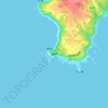
Nom : Carte topographique Shiono Cape, altitude, relief.
Altitude moyenne : 10 m
Altitude minimum : 0 m
Altitude maximum : 71 m
Faire un don
Équipez-vous pour votre prochaine aventure :
En tant que Partenaire Amazon, ce site perçoit une commission sur les achats éligibles sans surcoût pour vous.