
Carte topographique Pinabacdao
Cliquez sur la carte pour afficher l’altitude.
Pinabacdao
For administrative and statistical convenience, barangays are group into two districts - the Pinabacdao East District and Pinabacdao West District. The East district is composed of barangays situated in high altitude areas or those located in the eastern part of the municipality. Barangays located along Pan-Philippine Highway/National Road or commonly referred as Maharlika Highway (Tagalog: "Daang Maharlika") comprises the West District or those located along the western coastal and lowland areas. These districts have no form of any local government.
À propos de cette carte
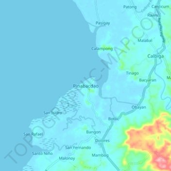
Nom : Carte topographique Pinabacdao, altitude, relief.
Lieu : Pinabacdao, Samar, Eastern Visayas, 6716, Philippines (11.57345 124.94368 11.65345 125.02368)
Altitude moyenne : 11 m
Altitude minimum : -3 m
Altitude maximum : 145 m
Autres cartes topographiques
Cliquez sur une carte pour visualiser sa topographie, son altitude et son relief.
Calbayog
Forty percent of the city's land area are plain and hilly terrains with elevation ranging from 5 to 20 metres (16 to 66 ft) above sea level. The rest are rugged mountain ranges with elevations from 300 to 700 metres (980 to 2,300 ft) above sea level. Flooding is minimized because of many rivers, brooks,…
Altitude moyenne : 78 m
Silanga District of Catbalogan City
Philippines > Samar > Silanga District of Catbalogan City
Altitude moyenne : 21 m
Calbayog
Forty percent of the city's land area are plain and hilly terrains with elevation ranging from 5 to 20 metres (16 to 66 ft) above sea level. The rest are rugged mountain ranges with elevations from 300 to 700 metres (980 to 2,300 ft) above sea level. Flooding is minimized because of many rivers, brooks,…
Altitude moyenne : 78 m