
Carte topographique Sichuan
Carte interactive
Cliquez sur la carte pour afficher l’altitude.
À propos de cette carte
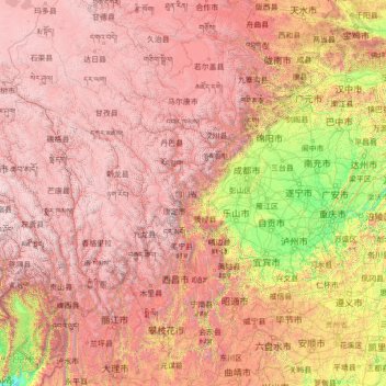
Nom : Carte topographique Sichuan, altitude, relief.
Lieu : Sichuan, China (26.04817 97.34738 34.31471 108.54267)
Altitude moyenne : 2.522 m
Altitude minimum : 140 m
Altitude maximum : 6.536 m
Due to great differences in terrain, the climate of the province is highly variable. In general, it has strong monsoonal influences, with rainfall heavily concentrated in the summer. Under the Köppen climate classification, the Sichuan Basin (including Chengdu) in the eastern half of the province experiences a humid subtropical climate (Köppen Cwa or Cfa), with long, hot, wet summers and short, mild to cool, dry, and cloudy winters. Consequently, it has China's lowest sunshine totals. The western region has mountainous areas producing a cooler but sunnier climate. Having cool to very cold winters and mild summers, temperatures generally decrease with greater elevation. However, due to its high altitude and its inland location, many areas such as Garze County and Zoige County in Sichuan exhibit a subarctic climate (Köppen Dwc)- featuring extremely cold winters down to −30 °C and even cold summer nights. The region is geologically active with landslides and earthquakes. Average elevation ranges from 2,000 to 3,500 meters; average temperatures range from 0 to 15 °C. The southern part of the province, including Panzhihua and Xichang, has a sunny climate with short, very mild winters and very warm to hot summers.
Autres cartes topographiques
Cliquez sur une carte pour visualiser sa topographie, son altitude et son relief.
Shangbaishui
China > Yunnan > Yulong Nakhi Autonomous County > Daju
Shangbaishui, Daju, Yulong Nakhi Autonomous County, Lijiang City, Yunnan, China
Altitude moyenne : 2.990 m
Taiping District
Taiping District, Fuxin City, Liaoning, 123000, China
Altitude moyenne : 235 m
Tazhong
China > Xinjiang > Qarqan County > Tazhong Town
Tazhong, Tazhong Town, Qarqan County, Bayingolin, Xinjiang, China
Altitude moyenne : 1.116 m
Nam Bin Wai
China > Hong Kong > Yuen Long District > Tai Kiu Village
Nam Bin Wai, Tai Kiu Village, Yuen Long District, New Territories, Hong Kong, China
Altitude moyenne : 16 m
CN/VN disputes in Paracel Islands
CN/VN disputes in Paracel Islands, Hainan Province, 573199, China
Altitude moyenne : 0 m
Lion mountain
China > Zhejiang > Hangzhou City
Lion mountain, Hangzhou City, Zhejiang, 310024, China
Altitude moyenne : 15 m
Keriya County
Keriya County, Hotan Prefecture, Xinjiang, 848400, China
Altitude moyenne : 2.410 m
Yau Oi Chuen
China > Hong Kong > Sha Tin District > Tung Lo Wan
Yau Oi Chuen, Tung Lo Wan, Sha Tin District, New Territories, Hong Kong, China
Altitude moyenne : 156 m
Wuhua District
Wuhua District, Kunming, Yunnan, China
Altitude moyenne : 2.104 m
Daxingnanjiecun
China > Henan > Tangyin County
Daxingnanjiecun, Tangyin County, Anyang, Henan, China
Altitude moyenne : 85 m
Ap Lei Chau
China > Hong Kong > Hong Kong Island
Ap Lei Chau, Southern District, Hong Kong Island, Hong Kong, China
Altitude moyenne : 25 m
Yaha
China > Gansu > Zhugqu County > Wuping
Yaha, Wuping, Zhugqu County, Gannan, Gansu, 746300, China
Altitude moyenne : 2.174 m
Huancui District
Huancui District, Weihai, Shandong, 264200, China
Altitude moyenne : 41 m
Tai Mo Shan
China > Hong Kong > Tsuen Wan District
Tai Mo Shan, Tsuen Wan District, New Territories, Hong Kong, China
Altitude moyenne : 600 m
Yiwu County
Yiwu County, Hami, Yiwu, Xinjiang, China
Altitude moyenne : 1.215 m
Kaba
China > Xinjiang > Habahe County > 阿克齐镇
Kaba, 阿克齐镇, Habahe County, Altay Prefecture, Xinjiang, China
Altitude moyenne : 557 m