
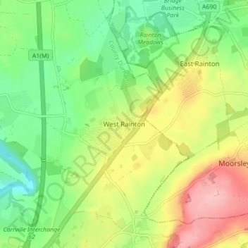
Carte topographique West Rainton
Carte interactive
Cliquez sur la carte pour afficher l’altitude.
À propos de cette carte
Nom : Carte topographique West Rainton, altitude, relief.
Altitude moyenne : 79 m
Altitude minimum : 20 m
Altitude maximum : 162 m
The following is from History, Topography and Directory of Durham, Whellan, London, 1894; "The village of West Rainton is about four miles north-east of Durham, and formerly contained an ancient chapel with chantry dedicated to the Virgin Mary; some of the old stones may be seen in the different buildings in the village. The Old Hall, situated in the centre of the village, was built about 1690, by Sir Jno. Buck, [sic] now in a state of dilapidation, and let in tenements occupied by pitmen. There is a library, reading, and news-room here. There are two batteries of the Second Durham Artillery Volunteers, having a drill-hall here, built by the Marquess of Londonderry in 1880, the headquarters being at Seaham Harbour."[6]
Autres cartes topographiques
Cliquez sur une carte pour visualiser sa topographie, son altitude et son relief.
Coxhoe
United Kingdom > England > County Durham
Coxhoe, County Durham, North East, England, United Kingdom
Altitude moyenne : 111 m
Consett
United Kingdom > England > County Durham
Consett, County Durham, North East, England, United Kingdom
Altitude moyenne : 205 m
Wycliffe
United Kingdom > England > County Durham
Wycliffe, Wycliffe with Thorpe, County Durham, North East, England, DL12 9TS, United Kingdom
Altitude moyenne : 129 m
Flint Hill
United Kingdom > England > County Durham
Flint Hill, County Durham, North East, England, DH9 9JW, United Kingdom
Altitude moyenne : 191 m
Bearpark
United Kingdom > England > County Durham > Bearpark
Bearpark, County Durham, North East, England, United Kingdom
Altitude moyenne : 106 m
Thornberry
United Kingdom > England > County Durham
Thornberry, Boldron, County Durham, North East, England, DL12 9JJ, United Kingdom
Altitude moyenne : 255 m
Seaham
United Kingdom > England > County Durham
Seaham, County Durham, North East, England, United Kingdom
Altitude moyenne : 31 m
Darlington
United Kingdom > England > County Durham
Darlington, County Durham, Tees Valley, England, DL1 5PW, United Kingdom
Altitude moyenne : 52 m
Tyne and Wear
United Kingdom > England > County Durham
Tyne and Wear, County Durham, North East, England, United Kingdom
Altitude moyenne : 82 m
Toronto
United Kingdom > England > County Durham > Toronto
Toronto, County Durham, North East, England, DL14 7RX, United Kingdom
Altitude moyenne : 107 m
Langton
United Kingdom > England > County Durham > Langton
Langton, County Durham, North East England, England, United Kingdom
Altitude moyenne : 105 m