
Faire un don
Équipez-vous pour votre prochaine aventure :
En tant que Partenaire Amazon, ce site perçoit une commission sur les achats éligibles sans surcoût pour vous.
Carte topographique Cho Oyu
Cliquez sur la carte pour afficher l’altitude.
Faire un don
Équipez-vous pour votre prochaine aventure :
En tant que Partenaire Amazon, ce site perçoit une commission sur les achats éligibles sans surcoût pour vous.
Cho Oyu
Cho Oyu's height was originally measured at 26,750 feet (8,150 m) and at the time of the first ascent it was considered the 7th highest mountain on earth, after Dhaulagiri at 8,167 metres (26,795 ft) (Manaslu, now 8,156 metres (26,759 ft), was also estimated lower at 26,658 feet (8,125 m)). A 1984 estimate of 8,201 metres (26,906 ft) made it move up to sixth place. New measurements made in 1996 by the Government of Nepal Survey Department and the Finnish Meteorological Institute in preparation for the Nepal Topographic Maps put the height at 8,188 m, one remarkably similar to the 26,867 feet (8,189 m) used by Edmund Hillary in his 1955 book High Adventure.
Faire un don
Équipez-vous pour votre prochaine aventure :
En tant que Partenaire Amazon, ce site perçoit une commission sur les achats éligibles sans surcoût pour vous.
À propos de cette carte
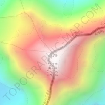
Nom : Carte topographique Cho Oyu, altitude, relief.
Altitude moyenne : 7.339 m
Altitude minimum : 6.425 m
Altitude maximum : 8.172 m
Faire un don
Équipez-vous pour votre prochaine aventure :
En tant que Partenaire Amazon, ce site perçoit une commission sur les achats éligibles sans surcoût pour vous.
Autres cartes topographiques
Cliquez sur une carte pour visualiser sa topographie, son altitude et son relief.
Shelkar
China > Tibet > Tingri County
The town lies 7 kilometres (4.3 mi) off the Friendship Highway between Lhatse and Tingri, at an altitude of about 4,300 metres (14,100 ft), at the southern foot of 5,260 metres (17,260 ft) high Gyatso La. It is approximately 60 kilometres (37 mi) north-west of Mount Everest and just over 50 kilometres (31 mi)…
Altitude moyenne : 4.831 m
Faire un don
Équipez-vous pour votre prochaine aventure :
En tant que Partenaire Amazon, ce site perçoit une commission sur les achats éligibles sans surcoût pour vous.