
Faire un don
Équipez-vous pour votre prochaine aventure :
En tant que Partenaire Amazon, ce site perçoit une commission sur les achats éligibles sans surcoût pour vous.
Carte topographique Marojejy National Park
Cliquez sur la carte pour afficher l’altitude.
Faire un don
Équipez-vous pour votre prochaine aventure :
En tant que Partenaire Amazon, ce site perçoit une commission sur les achats éligibles sans surcoût pour vous.
Marojejy National Park
Marojejy National Park (/məˈroʊdʒɛdʒiː/) is a national park in the Sava region of northeastern Madagascar. It covers 55,500 ha (214 sq mi) and is centered on the Marojejy Massif, a mountain chain that rises to an elevation of 2,132 m (6,995 ft). Access to the area around the massif was restricted to research scientists when the site was set aside as a strict nature reserve in 1952. In 1998, it was opened to the public when it was converted into a national park. It became part of the World Heritage Site known as the Rainforests of the Atsinanana in 2007. "Unique in the world, a place of dense, jungly rainforests, sheer high cliffs, and plants and animals found nowhere else on earth", Marojejy National Park has received plaudits in the New York Times and Smithsonian Magazine for its natural beauty and rich biodiversity that encompasses critically endangered members of the silky sifaka. To that end, a global consortium of conservation organizations, including the Lemur Conservation Foundation, Duke Lemur Center and Madagascar National Parks, have sought to promote research and conservation programs in Marojejy National Park, neighboring Anjanaharibe-Sud Reserve and Antanetiambo Private Reserve, to protect the endemic flora and fauna that reside in northeastern Madagascar. In addition, these organizations have implemented a variety of community-based initiatives to mitigate human encroachment on the park, such as poaching and selective logging, by encouraging local communities to engage in afforestation and silvicultural initiatives to promote a sustainable alternative to mining, slash-and-burn agriculture, and wood collection.
Faire un don
Équipez-vous pour votre prochaine aventure :
En tant que Partenaire Amazon, ce site perçoit une commission sur les achats éligibles sans surcoût pour vous.
À propos de cette carte
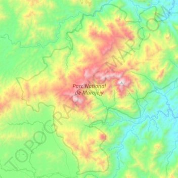
Nom : Carte topographique Marojejy National Park, altitude, relief.
Altitude moyenne : 675 m
Altitude minimum : 54 m
Altitude maximum : 2.108 m
Faire un don
Équipez-vous pour votre prochaine aventure :
En tant que Partenaire Amazon, ce site perçoit une commission sur les achats éligibles sans surcoût pour vous.
Autres cartes topographiques
Cliquez sur une carte pour visualiser sa topographie, son altitude et son relief.