
Faire un don
Équipez-vous pour votre prochaine aventure :
En tant que Partenaire Amazon, ce site perçoit une commission sur les achats éligibles sans surcoût pour vous.
Carte topographique Spring Hill
Cliquez sur la carte pour afficher l’altitude.
Faire un don
Équipez-vous pour votre prochaine aventure :
En tant que Partenaire Amazon, ce site perçoit une commission sur les achats éligibles sans surcoût pour vous.
À propos de cette carte
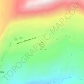
Nom : Carte topographique Spring Hill, altitude, relief.
Lieu : Spring Hill, Sanpete County, Utah, United States (39.15047 -111.56274 39.15057 -111.56264)
Altitude moyenne : 2.746 m
Altitude minimum : 2.408 m
Altitude maximum : 3.227 m
Faire un don
Équipez-vous pour votre prochaine aventure :
En tant que Partenaire Amazon, ce site perçoit une commission sur les achats éligibles sans surcoût pour vous.
Autres cartes topographiques
Cliquez sur une carte pour visualiser sa topographie, son altitude et son relief.
Manti
United States > Utah > Sanpete County
Manti has a humid continental climate (Köppen Dfb) with warm summers and cold winters, receiving on average barely enough rainfall to avoid a semi-arid classification (BSk). Its high elevation means that the climate is cooler than other populated areas of Utah, especially during summer. Summers highs average…
Altitude moyenne : 1.743 m
Faire un don
Équipez-vous pour votre prochaine aventure :
En tant que Partenaire Amazon, ce site perçoit une commission sur les achats éligibles sans surcoût pour vous.
Manti
United States > Utah > Sanpete County
Manti has a humid continental climate (Köppen Dfb) with warm summers and cold winters, receiving on average barely enough rainfall to avoid a semi-arid classification (BSk). Its high elevation means that the climate is cooler than other populated areas of Utah, especially during summer. Summers highs average…
Altitude moyenne : 1.743 m