
Carte topographique Lander County
Carte interactive
Cliquez sur la carte pour afficher l’altitude.
À propos de cette carte
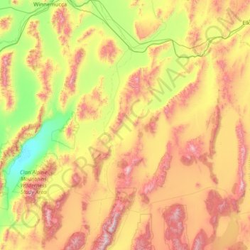
Nom : Carte topographique Lander County, altitude, relief.
Lieu : Lander County, Nevada, United States of America (39.09334 -117.80528 41.00114 -116.58745)
Altitude moyenne : 1.768 m
Altitude minimum : 1.030 m
Altitude maximum : 3.354 m
The 11,477 ft (3498 m) summit of Bunker Hill, located in the Toiyabe Range near the Nye County border, is the highest point in the county while the county's most topographically prominent peak is Mount Lewis.
Autres cartes topographiques
Cliquez sur une carte pour visualiser sa topographie, son altitude et son relief.
White Pine County
United States of America > Nevada
White Pine County, Nevada, United States of America
Altitude moyenne : 2.049 m
Churchill County
United States of America > Nevada
Churchill County, Nevada, United States of America
Altitude moyenne : 1.476 m
Washoe County
United States of America > Nevada
Washoe County, Nevada, United States of America
Altitude moyenne : 1.528 m