
Faire un don
Équipez-vous pour votre prochaine aventure :
En tant que Partenaire Amazon, ce site perçoit une commission sur les achats éligibles sans surcoût pour vous.
Carte topographique Black Jack Battlefield
Cliquez sur la carte pour afficher l’altitude.
Faire un don
Équipez-vous pour votre prochaine aventure :
En tant que Partenaire Amazon, ce site perçoit une commission sur les achats éligibles sans surcoût pour vous.
À propos de cette carte
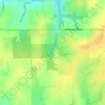
Nom : Carte topographique Black Jack Battlefield, altitude, relief.
Altitude moyenne : 332 m
Altitude minimum : 315 m
Altitude maximum : 343 m
Faire un don
Équipez-vous pour votre prochaine aventure :
En tant que Partenaire Amazon, ce site perçoit une commission sur les achats éligibles sans surcoût pour vous.
Autres cartes topographiques
Cliquez sur une carte pour visualiser sa topographie, son altitude et son relief.
Lawrence
United States > Kansas > Douglas County
Lawrence is located at coordinates 38.9716689, -95.2352501 in the state of Kansas, approximately 25 miles (40 kilometers) east of Topeka, and 35 mi (56 km) west of Kansas City, Kansas. Though Lawrence has a designated elevation of 866 feet (264 m), the highest elevation is Mount Oread on the University of…
Altitude moyenne : 265 m
Faire un don
Équipez-vous pour votre prochaine aventure :
En tant que Partenaire Amazon, ce site perçoit une commission sur les achats éligibles sans surcoût pour vous.
Lawrence
United States > Kansas > Douglas County
Lawrence is located at coordinates 38.9716689, -95.2352501 in the state of Kansas, approximately 25 miles (40 kilometers) east of Topeka, and 35 mi (56 km) west of Kansas City, Kansas. Though Lawrence has a designated elevation of 866 feet (264 m), the highest elevation is Mount Oread on the University of…
Altitude moyenne : 265 m
Faire un don
Équipez-vous pour votre prochaine aventure :
En tant que Partenaire Amazon, ce site perçoit une commission sur les achats éligibles sans surcoût pour vous.
Lawrence
United States > Kansas > Douglas County
Lawrence is located approximately 25 miles (40 kilometers) east of Topeka, and 35 mi (56 km) west of Kansas City, Kansas. Though Lawrence has a designated elevation of 866 feet (264 m), the highest elevation is Mount Oread on the University of Kansas campus with an elevation of 1,020 feet (310 m).
Altitude moyenne : 265 m
Lawrence
United States > Kansas > Douglas County
Lawrence is located approximately 25 miles (40 kilometers) east of Topeka, and 35 mi (56 km) west of Kansas City, Kansas. Though Lawrence has a designated elevation of 866 feet (264 m), the highest elevation is Mount Oread on the University of Kansas campus with an elevation of 1,020 feet (310 m).
Altitude moyenne : 265 m