
Carte topographique Almaty
Carte interactive
Cliquez sur la carte pour afficher l’altitude.
Almaty
Almaty continues as the major commercial and cultural centre of Kazakhstan, as well as its most populous and most cosmopolitan city. The city is located in the mountainous area of southern Kazakhstan near the border with Kyrgyzstan in the foothills of the Trans-Ili Alatau at an elevation of 700–900 m (2,300–3,000 feet), where the Large and Small Almatinka rivers run into the plain.
À propos de cette carte
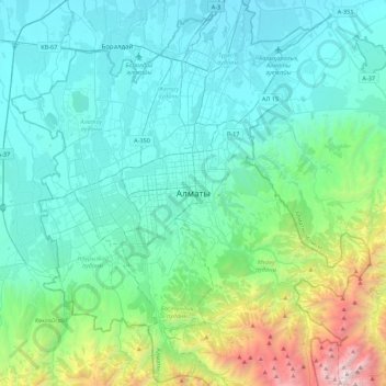
Nom : Carte topographique Almaty, altitude, relief.
Lieu : Almaty, Бостандыкский район, Almaty, 050013, Kazakhstan (43.07639 76.78573 43.39639 77.10573)
Altitude moyenne : 1.261 m
Altitude minimum : 633 m
Altitude maximum : 4.319 m
Autres cartes topographiques
Cliquez sur une carte pour visualiser sa topographie, son altitude et son relief.