
Carte topographique Candon
Carte interactive
Cliquez sur la carte pour afficher l’altitude.
Candon
Candon City is situated in the lower central portion of the Province of Ilocos Sur. It has a "C" shape with elevations ranging from 10 – 500 ft above sea level. The city is 346 kilometres (215 mi) from Metro Manila and 61 kilometres (38 mi) from Vigan City, the provincial capital.
À propos de cette carte
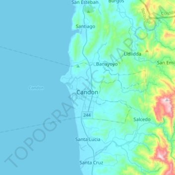
Nom : Carte topographique Candon, altitude, relief.
Lieu : Candon, Ilocos Sur, Ilocos Region, 2710, Philippines (17.12758 120.26173 17.27172 120.54281)
Altitude moyenne : 83 m
Altitude minimum : -2 m
Altitude maximum : 911 m
Autres cartes topographiques
Cliquez sur une carte pour visualiser sa topographie, son altitude et son relief.