
Carte topographique Godalming
Cliquez sur la carte pour afficher l’altitude.
Godalming
Elevations vary between 36 m (118 ft) AOD by the Guildford Road Rugby Union ground and Broadwater lake at the River Wey's exit from Godalming into Peasmarsh, Shalford, and 106 m (348 ft) AOD where Quarter Mile meets Hambledon Road (both residential) in the south-east. Hurtmore Road is also residential: Upper Green/Hurtmore is at 102 m (335 ft) AOD. Immediately north and south of the town centre, steep hills reach 95 m (312 ft) AOD from 40–45 m (131–148 ft) AOD in the town centre itself.
À propos de cette carte
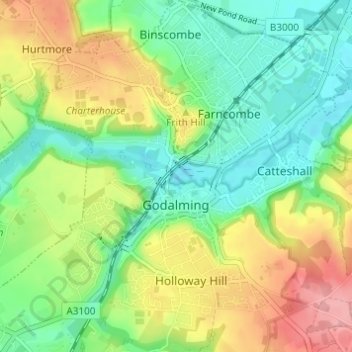
Nom : Carte topographique Godalming, altitude, relief.
Lieu : Godalming, Waverley, Surrey, England, United Kingdom (51.16986 -0.64093 51.20806 -0.58489)
Altitude moyenne : 71 m
Altitude minimum : 31 m
Altitude maximum : 133 m
Autres cartes topographiques
Cliquez sur une carte pour visualiser sa topographie, son altitude et son relief.
Camelsdale
United Kingdom > England > Surrey > Waverley > Haslemere > Shottermill
Altitude moyenne : 166 m