
Faire un don
Équipez-vous pour votre prochaine aventure :
En tant que Partenaire Amazon, ce site perçoit une commission sur les achats éligibles sans surcoût pour vous.
Carte topographique Sehana
Cliquez sur la carte pour afficher l’altitude.
Faire un don
Équipez-vous pour votre prochaine aventure :
En tant que Partenaire Amazon, ce site perçoit une commission sur les achats éligibles sans surcoût pour vous.
À propos de cette carte
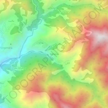
Nom : Carte topographique Sehana, altitude, relief.
Altitude moyenne : 1.968 m
Altitude minimum : 1.412 m
Altitude maximum : 2.631 m
Faire un don
Équipez-vous pour votre prochaine aventure :
En tant que Partenaire Amazon, ce site perçoit une commission sur les achats éligibles sans surcoût pour vous.
Autres cartes topographiques
Cliquez sur une carte pour visualiser sa topographie, son altitude et son relief.
Lora Tehsil
Pakistan > Khyber Pakhtunkhwa > Abbottābād District
Lora is located at an altitude of 1148 metres (3769 feet). It is situated in the southern part of Abbottabad District formerly part of Havelian Tehsil, it is now the headquarters of Lora Tehsil. It is bounded by the following union councils, Nara to the north, Nagri Totial to the north and east, Goreeni to the…
Altitude moyenne : 1.359 m