
Faire un don
Équipez-vous pour votre prochaine aventure :
En tant que Partenaire Amazon, ce site perçoit une commission sur les achats éligibles sans surcoût pour vous.
Carte topographique Villaricos
Cliquez sur la carte pour afficher l’altitude.
Faire un don
Équipez-vous pour votre prochaine aventure :
En tant que Partenaire Amazon, ce site perçoit une commission sur les achats éligibles sans surcoût pour vous.
À propos de cette carte
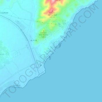
Nom : Carte topographique Villaricos, altitude, relief.
Altitude moyenne : 16 m
Altitude minimum : -3 m
Altitude maximum : 257 m
Faire un don
Équipez-vous pour votre prochaine aventure :
En tant que Partenaire Amazon, ce site perçoit une commission sur les achats éligibles sans surcoût pour vous.
Autres cartes topographiques
Cliquez sur une carte pour visualiser sa topographie, son altitude et son relief.
Seville
Seville has an area of 141 km2 (54 sq mi), according to the National Topographic Map (Mapa Topográfico Nacional) series from the Instituto Geográfico Nacional – Centro Nacional de Información Geográfica, the country's civilian survey organisation (pages 984, 985 and 1002). The city is situated in the…
Altitude moyenne : 35 m
Málaga
Spain > Andalusia > Málaga-Costa del Sol
Like many of the military fortifications that were constructed in Islamic Spain, the Alcazaba of Málaga featured a quadrangular plan. It was protected by an outer and inner wall, both supported by rectangular towers, between which a covered walkway led up the slope to the Gibralfaro (this was the only…
Altitude moyenne : 276 m
Faire un don
Équipez-vous pour votre prochaine aventure :
En tant que Partenaire Amazon, ce site perçoit une commission sur les achats éligibles sans surcoût pour vous.
Córdoba
The differences in elevation in the Valley are very small, ranging from 100 and 170 metres above sea level, with the city proper located at an average altitude of roughly 125 metres above sea level. The landscape of the valley is further subdivided in the piedmont connecting with the Sierra, the fluvial…
Altitude moyenne : 281 m
Ojén
Spain > Andalusia > Sierra de las Nieves
The town is situated beside the Almadán stream above the valley of the River Real at an altitude of approximately 200 metres, hemmed in by the Sierra Blanca and the Sierra Alpujata. These may provide a clue to the Moors' determination to stay in spite of their apparent antipathy, for both ranges of mountains…
Altitude moyenne : 404 m
Faire un don
Équipez-vous pour votre prochaine aventure :
En tant que Partenaire Amazon, ce site perçoit une commission sur les achats éligibles sans surcoût pour vous.
Granada
Spain > Andalusia > Comarca de la Vega de Granada
Granada (Spanish: [ɡɾaˈnaða], locally [ɡɾaˈna]) is the capital city of the province of Granada, in the autonomous community of Andalusia, Spain. Granada is located at the foot of the Sierra Nevada mountains, at the confluence of four rivers, the Darro, the Genil, the Monachil and the Beiro. Ascribed to…
Altitude moyenne : 829 m
Faire un don
Équipez-vous pour votre prochaine aventure :
En tant que Partenaire Amazon, ce site perçoit une commission sur les achats éligibles sans surcoût pour vous.
Marbella
Spain > Andalusia > Costa del Sol Occidental
There are five geomorphological units: the Sierra Blanca, the Sierra Blanca piedmont (foothills), the lower hill country, the plains and the coastal dunes. The Sierra Blanca is most centrally located in the province, looming over the old village. This mountain range has three peaks: La Concha, located further…
Altitude moyenne : 216 m
Faire un don
Équipez-vous pour votre prochaine aventure :
En tant que Partenaire Amazon, ce site perçoit une commission sur les achats éligibles sans surcoût pour vous.
Alhambra
Spain > Andalusia > Partido Judicial de Granada > Granada
During the reign of the Nasrid Dynasty, the Alhambra was transformed into a palatine city, complete with an irrigation system composed of aqueducts and water channels that provided water for the complex and for other nearby countryside palaces such as the Generalife. Previously, the old fortresses on the hill…
Altitude moyenne : 759 m
Baeza
The town stands at a high elevation about 3 miles (4.8 km) from the right bank of the Guadalquivir in the Loma de Úbeda. Under the Romans, the town was known as 'Beatia'. Following its conquest by the Visigoths, Beatia was the seat of a bishopric of Baeza (viz.). From the beginning of the seventh century it…
Altitude moyenne : 485 m
Faire un don
Équipez-vous pour votre prochaine aventure :
En tant que Partenaire Amazon, ce site perçoit une commission sur les achats éligibles sans surcoût pour vous.
Málaga
Spain > Andalusia > Málaga-Costa del Sol
Like many of the military fortifications that were constructed in Islamic Spain, the Alcazaba of Málaga featured a quadrangular plan. It was protected by an outer and inner wall, both supported by rectangular towers, between which a covered walkway led up the slope to the Gibralfaro (this was the only…
Altitude moyenne : 276 m
Faire un don
Équipez-vous pour votre prochaine aventure :
En tant que Partenaire Amazon, ce site perçoit une commission sur les achats éligibles sans surcoût pour vous.
Faire un don
Équipez-vous pour votre prochaine aventure :
En tant que Partenaire Amazon, ce site perçoit une commission sur les achats éligibles sans surcoût pour vous.
Parque Nacional de Sierra Nevada
Spain > Andalusia > Comarca de la Alpujarra Granadina
The Sierra Nevada Ski Station, which hosted the Alpine World Ski Championships in 1996, is Europe's southernmost ski resort. Thanks to its high altitude, the skiing season can last from late November until the start of May.
Altitude moyenne : 1.176 m
Málaga
Spain > Andalusia > Málaga-Costa del Sol
Like many of the military fortifications that were constructed in Islamic Spain, the Alcazaba of Málaga featured a quadrangular plan. It was protected by an outer and inner wall, both supported by rectangular towers, between which a covered walkway led up the slope to the Gibralfaro (this was the only…
Altitude moyenne : 276 m
Canillas de Aceituno
Spain > Andalusia > La Axarquía
Canillas de Aceituno has an altitude of around 524 meters at the foot of the Sierra de Tejeda and is crowned by the peak of La Maroma at 2,068 meters, the highest in the province. It is a town of narrow streets that are immaculately whitewashed, Moorish arches and corners of flowers.
Altitude moyenne : 677 m
Faire un don
Équipez-vous pour votre prochaine aventure :
En tant que Partenaire Amazon, ce site perçoit une commission sur les achats éligibles sans surcoût pour vous.
Cómpeta
Spain > Andalusia > La Axarquía
The highest point visible from the town is the Maroma (2,065 m). The topography of the terminus is quite hilly, especially in the northwest, which borders the province of Granada. Other important elevations are Cerro Lucero (1,779 m), Cisne (1,600 m), Verde (1,554 m) and Tajo de las Grajas, which has a length…
Altitude moyenne : 694 m
Granada
Spain > Andalusia > Comarca de la Vega de Granada
Granada (/ɡrəˈnɑːdə/ grə-NAH-də; Spanish: [ɡɾaˈnaða] ) is the capital city of the province of Granada, in the autonomous community of Andalusia, Spain. Granada is located at the foot of the Sierra Nevada mountains, at the confluence of four rivers, the Darro, the Genil, the Monachil and the Beiro.…
Altitude moyenne : 829 m
Faire un don
Équipez-vous pour votre prochaine aventure :
En tant que Partenaire Amazon, ce site perçoit une commission sur les achats éligibles sans surcoût pour vous.
Faire un don
Équipez-vous pour votre prochaine aventure :
En tant que Partenaire Amazon, ce site perçoit une commission sur les achats éligibles sans surcoût pour vous.
Faire un don
Équipez-vous pour votre prochaine aventure :
En tant que Partenaire Amazon, ce site perçoit une commission sur les achats éligibles sans surcoût pour vous.
Faire un don
Équipez-vous pour votre prochaine aventure :
En tant que Partenaire Amazon, ce site perçoit une commission sur les achats éligibles sans surcoût pour vous.
Lucena
Lucena is located in the transition zone between the campiña in the Guadalquivir Depression and the Subbaetic system, at an altitude above mean sea level slightly below 500 meters. The Subbaetic system include neighboring subranges such as the sierras of Cabra, Carcabuey, Pollos, Horconera, and Rute.
Altitude moyenne : 476 m
Faire un don
Équipez-vous pour votre prochaine aventure :
En tant que Partenaire Amazon, ce site perçoit une commission sur les achats éligibles sans surcoût pour vous.
Seville
Seville has an area of 141 km2 (54 sq mi), according to the National Topographic Map (Mapa Topográfico Nacional) series from the Instituto Geográfico Nacional – Centro Nacional de Información Geográfica, the country's civilian survey organisation (pages 984, 985 and 1002). The city is situated in the…
Altitude moyenne : 35 m
Capileira
Spain > Andalusia > Comarca de la Alpujarra Granadina
Capileira is the highest and most northerly of the three villages in the gorge of the Poqueira river in the La Alpujarra district of the province of Granada, in Spain. It is located at latitude 36° 57' N and longitude 3° 21' W, about 1 km north of Bubión. Its altitude is officially recorded as 1436 metres,…
Altitude moyenne : 2.384 m
Faire un don
Équipez-vous pour votre prochaine aventure :
En tant que Partenaire Amazon, ce site perçoit une commission sur les achats éligibles sans surcoût pour vous.
Málaga
Spain > Andalusia > Málaga-Costa del Sol
Like many of the military fortifications that were constructed in Islamic Spain, the Alcazaba of Málaga featured a quadrangular plan. It was protected by an outer and inner wall, both supported by rectangular towers, between which a covered walkway led up the slope to the Gibralfaro (this was the only…
Altitude moyenne : 276 m
Mijas
Spain > Andalusia > Costa del Sol Occidental
The climate changes gradually with increasing elevation in the mountains. Temperatures can drop to 10 °C (50 °F). In the peaks, over 600 m (2,000 ft) high, some ice may form in winter, while precipitation increases to almost 800 mm (32 in).
Altitude moyenne : 171 m
Faire un don
Équipez-vous pour votre prochaine aventure :
En tant que Partenaire Amazon, ce site perçoit une commission sur les achats éligibles sans surcoût pour vous.
Cómpeta
Spain > Andalusia > La Axarquía
The highest point visible from the town is the Maroma (2,065 m). The topography of the terminus is quite hilly, especially in the northwest, which borders the province of Granada. Other important elevations are Cerro Lucero (1,779 m), Cisne (1,600 m), Verde (1,554 m) and Tajo de las Grajas, which has a length…
Altitude moyenne : 694 m
Trevélez
Spain > Andalusia > Comarca de la Alpujarra Granadina
The river Trevélez flows through the village, which lies at the confluence of the river with a smaller stream. It is divided into three parts, the Barrios Bajo, Medio and Alto (lower, mid and upper quarters), with 200 metres of altitude difference between the highest and lowest points. The only bridge over…
Altitude moyenne : 2.351 m
Faire un don
Équipez-vous pour votre prochaine aventure :
En tant que Partenaire Amazon, ce site perçoit une commission sur les achats éligibles sans surcoût pour vous.
Cádiz
Spain > Andalusia > Bay of Cádiz
The Baluarte de la Candelaria (fortress or stronghold of Candlemas) is a military fortification. Taking advantage of a natural elevation of land, it was constructed in 1672 at the initiative of the governor, Diego Caballero de Illescas. Protected by a seaward-facing wall that had previously served as a…
Altitude moyenne : 1 m
Faire un don
Équipez-vous pour votre prochaine aventure :
En tant que Partenaire Amazon, ce site perçoit une commission sur les achats éligibles sans surcoût pour vous.
Faire un don
Équipez-vous pour votre prochaine aventure :
En tant que Partenaire Amazon, ce site perçoit une commission sur les achats éligibles sans surcoût pour vous.
Faire un don
Équipez-vous pour votre prochaine aventure :
En tant que Partenaire Amazon, ce site perçoit une commission sur les achats éligibles sans surcoût pour vous.
Faire un don
Équipez-vous pour votre prochaine aventure :
En tant que Partenaire Amazon, ce site perçoit une commission sur les achats éligibles sans surcoût pour vous.
Córdoba
The differences in elevation in the Valley are very small, ranging from 100 and 170 metres above sea level, with the city proper located at an average altitude of roughly 125 metres above sea level. The landscape of the valley is further subdivided in the piedmont connecting with the Sierra, the fluvial…
Altitude moyenne : 281 m
Faire un don
Équipez-vous pour votre prochaine aventure :
En tant que Partenaire Amazon, ce site perçoit une commission sur les achats éligibles sans surcoût pour vous.
Faire un don
Équipez-vous pour votre prochaine aventure :
En tant que Partenaire Amazon, ce site perçoit une commission sur les achats éligibles sans surcoût pour vous.
Sierra de la Huerta del Abad
Spain > Andalusia > Sierra de Huelva > Aracena > Carboneras
Altitude moyenne : 525 m
Córdoba
The differences in elevation in the Valley are very small, ranging from 100 and 170 metres above sea level, with the city proper located at an average altitude of roughly 125 metres above sea level. The landscape of the valley is further subdivided in the piedmont connecting with the Sierra, the fluvial…
Altitude moyenne : 281 m
Seville
Seville has an area of 141 km2 (54 sq mi), according to the National Topographic Map (Mapa Topográfico Nacional) series from the Instituto Geográfico Nacional – Centro Nacional de Información Geográfica, the country's civilian survey organisation (pages 984, 985 and 1002). The city is situated in the…
Altitude moyenne : 35 m
Faire un don
Équipez-vous pour votre prochaine aventure :
En tant que Partenaire Amazon, ce site perçoit une commission sur les achats éligibles sans surcoût pour vous.
Faire un don
Équipez-vous pour votre prochaine aventure :
En tant que Partenaire Amazon, ce site perçoit une commission sur les achats éligibles sans surcoût pour vous.
Villarrasa
Spain > Andalusia > El Condado
Villarrasa is a town and a municipality at the same time. It is located in the province of Huelva, Spain. According to the 2005 census, it had a population of 2095 inhabitants and covers an area of 72 km2 (28 sq mi) (29.1 people/km2). It sits at an altitude of 65 m (213 ft) above sea level, and is 37 km (23…
Altitude moyenne : 91 m
Linares
Linares (Spanish pronunciation: [liˈnaɾes]) is a municipality of Spain belonging to the province of Jaén, Andalusia. It is the second-largest city in that province, with a population of 55,261 in the most recent census (2024). The altitude is 419 metres (1,375 feet) and the total area of the municipality is…
Altitude moyenne : 372 m
Palace of Charles V
Spain > Andalusia > Comarca de la Vega de Granada > Granada
Altitude moyenne : 752 m
Faire un don
Équipez-vous pour votre prochaine aventure :
En tant que Partenaire Amazon, ce site perçoit une commission sur les achats éligibles sans surcoût pour vous.