
Faire un don
Équipez-vous pour votre prochaine aventure :
En tant que Partenaire Amazon, ce site perçoit une commission sur les achats éligibles sans surcoût pour vous.
Carte topographique Hancock
Cliquez sur la carte pour afficher l’altitude.
Faire un don
Équipez-vous pour votre prochaine aventure :
En tant que Partenaire Amazon, ce site perçoit une commission sur les achats éligibles sans surcoût pour vous.
À propos de cette carte
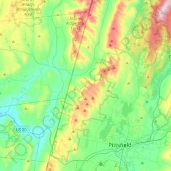
Nom : Carte topographique Hancock, altitude, relief.
Lieu : Hancock, Berkshire County, Massachusetts, United States (42.41857 -73.38356 42.63264 -73.25828)
Altitude moyenne : 416 m
Altitude minimum : 185 m
Altitude maximum : 983 m
Faire un don
Équipez-vous pour votre prochaine aventure :
En tant que Partenaire Amazon, ce site perçoit une commission sur les achats éligibles sans surcoût pour vous.
Autres cartes topographiques
Cliquez sur une carte pour visualiser sa topographie, son altitude et son relief.
Mount Everett
United States > Massachusetts > Berkshire County
Mount Everett helps divide the watersheds of the Hudson and Housatonic rivers. Its eastern slopes share a larger escarpment with Mount Race and Bear Mountain plus several related summits. This escarpment rises from an elevation around 700 feet in Sheffield's Housatonic Valley at a mean angle of about 20…
Altitude moyenne : 561 m
Hephzibah Heights
United States > Massachusetts > Berkshire County > Monterey
Altitude moyenne : 457 m
Mount Greylock
United States > Massachusetts > Berkshire County > Adams
Geographically, Mount Greylock is part of an 11-mile-long (18 km) by 4+1⁄2-mile-wide (7 km) island-like range that runs north-south between the Hoosac Range to the east, the Green Mountains to the north, the Berkshires to both the south and east, and the Taconic Mountains to the west with which it is…
Altitude moyenne : 746 m
Faire un don
Équipez-vous pour votre prochaine aventure :
En tant que Partenaire Amazon, ce site perçoit une commission sur les achats éligibles sans surcoût pour vous.
Southfield
United States > Massachusetts > Berkshire County > New Marlborough
Altitude moyenne : 405 m
Berkshire Heights
United States > Massachusetts > Berkshire County > Great Barrington
Altitude moyenne : 243 m
Faire un don
Équipez-vous pour votre prochaine aventure :
En tant que Partenaire Amazon, ce site perçoit une commission sur les achats éligibles sans surcoût pour vous.
Pittsfield
United States > Massachusetts > Berkshire County
Pittsfield has a humid continental climate (Dfb). Winters are harsh due the city's high elevation at 1,039 ft (317 m), with an average annual snowfall of 75.9 inches (1,930 mm) and temperatures dipping to 0 °F (−18 °C) or colder 13 times per year. Summers, however, are typically warm and pleasant, with…
Altitude moyenne : 433 m
Mount Greylock
United States > Massachusetts > Berkshire County > Adams
Northern hardwood forest characterize lower and mid-elevations, while upper slopes are covered with balsam fir and red spruce as well as American mountain ash. About 555 acres (225 hectares) of old growth forest have been inventoried within the Greylock Range, including tree specimens up to 350 years old. On…
Altitude moyenne : 746 m
Yankee Orchards
United States > Massachusetts > Berkshire County > Pittsfield
Altitude moyenne : 344 m
Faire un don
Équipez-vous pour votre prochaine aventure :
En tant que Partenaire Amazon, ce site perçoit une commission sur les achats éligibles sans surcoût pour vous.
State Line
United States > Massachusetts > Berkshire County > West Stockbridge
Altitude moyenne : 344 m
Clover Hill Farm Conservation Area
United States > Massachusetts > Berkshire County > Williamstown > Meadowvale
Altitude moyenne : 217 m
Faire un don
Équipez-vous pour votre prochaine aventure :
En tant que Partenaire Amazon, ce site perçoit une commission sur les achats éligibles sans surcoût pour vous.
Risingdale
United States > Massachusetts > Berkshire County > Great Barrington
Altitude moyenne : 277 m
Brookside
United States > Massachusetts > Berkshire County > Great Barrington
Altitude moyenne : 284 m
Faire un don
Équipez-vous pour votre prochaine aventure :
En tant que Partenaire Amazon, ce site perçoit une commission sur les achats éligibles sans surcoût pour vous.
Richmond Pond
United States > Massachusetts > Berkshire County > Richmond > Camp Russell
Altitude moyenne : 353 m
March Cataract Falls
United States > Massachusetts > Berkshire County > Williamstown
Altitude moyenne : 765 m
Greylock
United States > Massachusetts > Berkshire County > North Adams > Greylock
Altitude moyenne : 314 m
Faire un don
Équipez-vous pour votre prochaine aventure :
En tant que Partenaire Amazon, ce site perçoit une commission sur les achats éligibles sans surcoût pour vous.
Mountain Meadow Preserve
United States > Massachusetts > Berkshire County > Williamstown
Altitude moyenne : 267 m
Housatonic
United States > Massachusetts > Berkshire County > Great Barrington
Altitude moyenne : 291 m
Faire un don
Équipez-vous pour votre prochaine aventure :
En tant que Partenaire Amazon, ce site perçoit une commission sur les achats éligibles sans surcoût pour vous.
Mount Frissell
United States > Massachusetts > Berkshire County > Mount Washington
Altitude moyenne : 614 m