
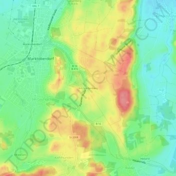
Carte topographique Am Schillenberg
Carte interactive
Cliquez sur la carte pour afficher l’altitude.
À propos de cette carte
Nom : Carte topographique Am Schillenberg, altitude, relief.
Altitude moyenne : 748 m
Altitude minimum : 711 m
Altitude maximum : 800 m
Autres cartes topographiques
Cliquez sur une carte pour visualiser sa topographie, son altitude et son relief.
Mühlbichel
Deutschland > Bayern > Landkreis Ostallgäu > Marktoberdorf > Ronried
Mühlbichel, Ronried, Marktoberdorf, Landkreis Ostallgäu, Bayern, 87616, Deutschland
Altitude moyenne : 769 m
Geisenried
Deutschland > Bayern > Landkreis Ostallgäu > Marktoberdorf
Geisenried, Marktoberdorf, Landkreis Ostallgäu, Bayern, 87616, Deutschland
Altitude moyenne : 753 m
Bertoldshofen
Deutschland > Bayern > Landkreis Ostallgäu > Marktoberdorf
Bertoldshofen, Marktoberdorf, Landkreis Ostallgäu, Bayern, 87616, Deutschland
Altitude moyenne : 752 m
Sulzschneid
Deutschland > Bayern > Landkreis Ostallgäu > Marktoberdorf
Sulzschneid, Marktoberdorf, Landkreis Ostallgäu, Bayern, 87663, Deutschland
Altitude moyenne : 775 m