
Carte topographique Weggis
Carte interactive
Cliquez sur la carte pour afficher l’altitude.
À propos de cette carte
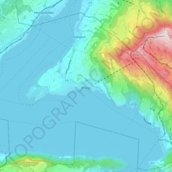
Nom : Carte topographique Weggis, altitude, relief.
Lieu : Weggis, Lucerne, Switzerland (47.01133 8.36850 47.05469 8.48043)
Altitude moyenne : 651 m
Altitude minimum : 424 m
Altitude maximum : 1.791 m
The town of Weggis lies on a south-facing plain on the shore of Lake Lucerne. Formerly, the town consisted of only two communities, Unterdorf in the west and Oberdorf in the east. Because of development in the last decades, new communities have developed: Hinterdorf (east of Oberdorf), Rain and Laugneri (near Hinterdorf), Baumen and Dörfli near Unterdorf, as well as Tischital and Rigiblick on the slope above Oberdorf. The community of Hertenstein (2.3 km (1.4 mi) south-west of the town, on the lake shore) lies in the extreme south-west corner of the municipality, on a peninsula. On the municipal border with Vitznau, 1.9 km (1.2 mi) south-east of the town, another quasi-community has developed. From the lake shore at elevation 436 m (1,430 ft) to an elevation of 794 m (2,605 ft), several hamlets have grown together. They are: Riedsort (on the lake shore), Bannholz (elev. 667 m (2,188 ft)), Bodenberg (elev. 642 m (2,106 ft)), and Sentiberg (elev. 794 m (2,605 ft)). High up the slope, accessible by cog railway and aerial tramway, lies the community of Rigi Kaltbad (2.8 km (1.7 mi) north-east of the town, elev. c. 1,450 m (4,760 ft)). Many other neighborhoods and single farmsteads belong to the municipality.
Autres cartes topographiques
Cliquez sur une carte pour visualiser sa topographie, son altitude et son relief.
Schloss Meggenhorn
Switzerland > Lucerne > Meggen
Schloss Meggenhorn, 53, Meggenhornstrasse, Lerchenbühl, Meggen, Lucerne, 6045, Switzerland
Altitude moyenne : 450 m
Allmendhubel
Switzerland > Lucerne > Menznau
Allmendhubel, Allmend, Menznau, Lucerne, 6122, Switzerland
Altitude moyenne : 636 m
Schachen
Switzerland > Lucerne > Werthenstein > Schachen
Schachen, Werthenstein, Lucerne, 6105, Switzerland
Altitude moyenne : 671 m