
Faire un don
Équipez-vous pour votre prochaine aventure :
En tant que Partenaire Amazon, ce site perçoit une commission sur les achats éligibles sans surcoût pour vous.
Carte topographique Oberried
Cliquez sur la carte pour afficher l’altitude.
Faire un don
Équipez-vous pour votre prochaine aventure :
En tant que Partenaire Amazon, ce site perçoit une commission sur les achats éligibles sans surcoût pour vous.
Oberried
The Schauinsland (literally "look-into-the-country"; near Freiburg im Breisgau, Germany) is a mountain in the Black Forest with an elevation of 1,284 m (4,213 ft) above sea level. It is a popular destination for day trips. Due to the high amount of silver mining, it was previously known as "Erzkasten" (literally "ore box"); the name "Schouwesland" first appeared in 1347. The mountain is located roughly ten kilometres (6.2 miles) south-east of Freiburg's city centre.
Faire un don
Équipez-vous pour votre prochaine aventure :
En tant que Partenaire Amazon, ce site perçoit une commission sur les achats éligibles sans surcoût pour vous.
À propos de cette carte
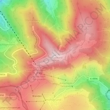
Nom : Carte topographique Oberried, altitude, relief.
Altitude moyenne : 1.068 m
Altitude minimum : 740 m
Altitude maximum : 1.279 m
Faire un don
Équipez-vous pour votre prochaine aventure :
En tant que Partenaire Amazon, ce site perçoit une commission sur les achats éligibles sans surcoût pour vous.
Autres cartes topographiques
Cliquez sur une carte pour visualiser sa topographie, son altitude et son relief.
Neuenburg am Rhein
Germany > Baden-Württemberg > Landkreis Breisgau-Hochschwarzwald
Altitude moyenne : 255 m
Dittishausen
Germany > Baden-Württemberg > Landkreis Breisgau-Hochschwarzwald > Löffingen
Altitude moyenne : 816 m
Müllheim
Germany > Baden-Württemberg > Landkreis Breisgau-Hochschwarzwald > Müllheim im Markgräflerland
Altitude moyenne : 268 m
Faire un don
Équipez-vous pour votre prochaine aventure :
En tant que Partenaire Amazon, ce site perçoit une commission sur les achats éligibles sans surcoût pour vous.
Feldberg
Germany > Baden-Württemberg > Landkreis Breisgau-Hochschwarzwald
Feldberg is a municipality in the district of Breisgau-Hochschwarzwald in Baden-Württemberg in southern Germany. It is located near the Feldberg, the highest summit in Baden-Württemberg. It comprises the settlements of Altglashütten, Neuglashütten, Falkau, Bärental, and Feldberg. At an elevation of 1,277…
Altitude moyenne : 1.071 m
Naturfreibad Sankt Märgen
Germany > Baden-Württemberg > Landkreis Breisgau-Hochschwarzwald > St. Märgen
Altitude moyenne : 893 m