
Faire un don
Équipez-vous pour votre prochaine aventure :
En tant que Partenaire Amazon, ce site perçoit une commission sur les achats éligibles sans surcoût pour vous.
Carte topographique Bottesford
Cliquez sur la carte pour afficher l’altitude.
Faire un don
Équipez-vous pour votre prochaine aventure :
En tant que Partenaire Amazon, ce site perçoit une commission sur les achats éligibles sans surcoût pour vous.
Bottesford
Bottesford's many listed buildings include the grade I listed 13th-century Church of St Mary the Virgin. There are two scheduled monuments within the village – Fleming's Bridge and the stone cross in the Market Place. The stocks and whipping post are Grade II listed. One of the Grade II listed buildings, Providence Cottage in Rectory Lane, is dated 1723 in burnt bricks on the eastern elevation, where the initials REH set into wall. The roof is now pantiled, but the slope suggests it was thatched in times gone by. The Duke of Rutland's Almshouse, also Grade II listed, was begun in 1590 and was a home for elderly local men called bedesmen (i. e. almoners), having once been a hospital. The building has two M-shaped roofs of differing pitches, both with concrete tiles dating from 1985. The Rectory, Grade II listed, is an ironstone and brick building dated 1708, enlarged in the 19th century and altered in 1988. It stands in Rectory Lane behind wrought iron gates, amid large, landscaped gardens, and has a slate roof. The police station, in Queen Street, is likewise Grade II listed and dates from 1846. It is in red brick with a slate roof and three bays. The central bay projects under a pediment and the building is an early example of a purpose-built police station. Market Street is the location of the Grade II listed Dr Fleming's House, which was once a terrace of women's almshouses built in ironstone and mainly rebuilt in brick in the late 18th century. A stone plaque over a door reads "Dr. Fleming's Hospital 1620". There are several Grade II listed properties in High Street, including the Thatched Restaurant, set back from the road in spacious grounds and the only remaining thatched building in the village.
Faire un don
Équipez-vous pour votre prochaine aventure :
En tant que Partenaire Amazon, ce site perçoit une commission sur les achats éligibles sans surcoût pour vous.
À propos de cette carte
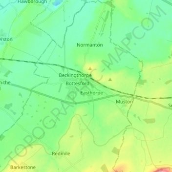
Nom : Carte topographique Bottesford, altitude, relief.
Altitude moyenne : 39 m
Altitude minimum : 8 m
Altitude maximum : 115 m
Faire un don
Équipez-vous pour votre prochaine aventure :
En tant que Partenaire Amazon, ce site perçoit une commission sur les achats éligibles sans surcoût pour vous.
Autres cartes topographiques
Cliquez sur une carte pour visualiser sa topographie, son altitude et son relief.
Faire un don
Équipez-vous pour votre prochaine aventure :
En tant que Partenaire Amazon, ce site perçoit une commission sur les achats éligibles sans surcoût pour vous.
Faire un don
Équipez-vous pour votre prochaine aventure :
En tant que Partenaire Amazon, ce site perçoit une commission sur les achats éligibles sans surcoût pour vous.
Langham Brook
United Kingdom > England > Leicestershire > Melton > Saxby > Freeby
Altitude moyenne : 94 m
Faire un don
Équipez-vous pour votre prochaine aventure :
En tant que Partenaire Amazon, ce site perçoit une commission sur les achats éligibles sans surcoût pour vous.
Faire un don
Équipez-vous pour votre prochaine aventure :
En tant que Partenaire Amazon, ce site perçoit une commission sur les achats éligibles sans surcoût pour vous.
Faire un don
Équipez-vous pour votre prochaine aventure :
En tant que Partenaire Amazon, ce site perçoit une commission sur les achats éligibles sans surcoût pour vous.
Faire un don
Équipez-vous pour votre prochaine aventure :
En tant que Partenaire Amazon, ce site perçoit une commission sur les achats éligibles sans surcoût pour vous.
Faire un don
Équipez-vous pour votre prochaine aventure :
En tant que Partenaire Amazon, ce site perçoit une commission sur les achats éligibles sans surcoût pour vous.
Faire un don
Équipez-vous pour votre prochaine aventure :
En tant que Partenaire Amazon, ce site perçoit une commission sur les achats éligibles sans surcoût pour vous.