
Carte topographique Daly City
Carte interactive
Cliquez sur la carte pour afficher l’altitude.
À propos de cette carte
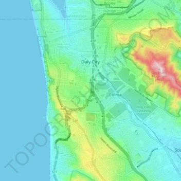
Nom : Carte topographique Daly City, altitude, relief.
Lieu : Daly City, San Mateo County, California, United States (37.64852 -122.50082 37.70827 -122.40514)
Altitude moyenne : 75 m
Altitude minimum : 0 m
Altitude maximum : 376 m
Several golf courses are located within or straddle the border with San Francisco. The Olympic Club has hosted the USGA U.S. Open five times, most recently in 2012, and will host both the 2028 PGA Championship and the 2032 Ryder Cup. The private San Francisco Golf Club and Lake Merced Golf Club have part or all of their course in Daly City. The Golden Gate National Recreation Area includes the city's Thornton Beach. The topography of this area (due to the San Andreas fault) is conducive to paragliding and hang gliding.
Autres cartes topographiques
Cliquez sur une carte pour visualiser sa topographie, son altitude et son relief.
Pacifica
United States > California > San Mateo County
Pacifica, San Mateo County, California, 94044, United States
Altitude moyenne : 76 m
City Hall Park
United States > California > San Mateo County > San Carlos
City Hall Park, San Carlos, San Mateo County, CAL Fire Northern Region, California, United States
Altitude moyenne : 33 m