
Carte topographique Champaign County
Carte interactive
Cliquez sur la carte pour afficher l’altitude.
À propos de cette carte
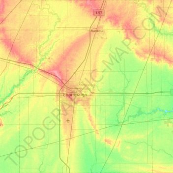
Nom : Carte topographique Champaign County, altitude, relief.
Lieu : Champaign County, Illinois, United States of America (39.87910 -88.46357 40.40068 -87.92882)
Altitude moyenne : 217 m
Altitude minimum : 187 m
Altitude maximum : 260 m
The topography of Champaign County was formed by the Wisconsin Glacier about 20,000 years before the present. Lobes of ice from what is now Lake Michigan crossed the county, creating a deep pile of glacial soil, up to 300 feet thick, topped by numerous moraines forming small, flat watersheds with no outlets.
Autres cartes topographiques
Cliquez sur une carte pour visualiser sa topographie, son altitude et son relief.
Deerfield
United States of America > Illinois > Deerfield
Deerfield, Illinois, United States of America
Altitude moyenne : 204 m
Mount Vernon
United States of America > Illinois > Mount Vernon
Mount Vernon, Jefferson County, Illinois, 62864, United States of America
Altitude moyenne : 147 m
Vergennes
United States of America > Illinois > Vergennes
Vergennes, Jackson County, Illinois, United States of America
Altitude moyenne : 121 m
Woodford
United States of America > Illinois > Woodford
Woodford, Woodford County, Illinois, United States of America
Altitude moyenne : 220 m
Wayne County
United States of America > Illinois
Wayne County, Illinois, United States of America
Altitude moyenne : 133 m
Douglas County
United States of America > Illinois
Douglas County, Illinois, United States of America
Altitude moyenne : 204 m