
Faire un don
Équipez-vous pour votre prochaine aventure :
En tant que Partenaire Amazon, ce site perçoit une commission sur les achats éligibles sans surcoût pour vous.
Carte topographique Spruce Mountain
Cliquez sur la carte pour afficher l’altitude.
Faire un don
Équipez-vous pour votre prochaine aventure :
En tant que Partenaire Amazon, ce site perçoit une commission sur les achats éligibles sans surcoût pour vous.
À propos de cette carte
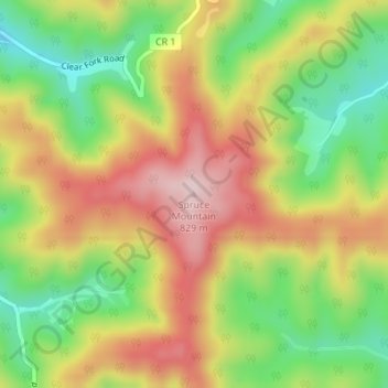
Nom : Carte topographique Spruce Mountain, altitude, relief.
Altitude moyenne : 669 m
Altitude minimum : 516 m
Altitude maximum : 825 m
Faire un don
Équipez-vous pour votre prochaine aventure :
En tant que Partenaire Amazon, ce site perçoit une commission sur les achats éligibles sans surcoût pour vous.
Autres cartes topographiques
Cliquez sur une carte pour visualiser sa topographie, son altitude et son relief.
Beckley
United States > West Virginia > Raleigh County
Due to its elevation, the climate of Beckley is humid subtropical (Köppen Cfa) bordering on both an oceanic (Köppen Cfb) and humid continental (Köppen Dfa/Dfb), and the city straddles the border between USDA Plant Hardiness Zones 6B and 7A. Summers are warm and humid, usually a few degrees cooler than…
Altitude moyenne : 723 m
Faire un don
Équipez-vous pour votre prochaine aventure :
En tant que Partenaire Amazon, ce site perçoit une commission sur les achats éligibles sans surcoût pour vous.
Beckley
United States > West Virginia > Raleigh County
Due to its elevation, the climate of Beckley is humid subtropical (Köppen Cfa) bordering on both an oceanic (Köppen Cfb) and humid continental (Köppen Dfa/Dfb), and the city straddles the border between USDA Plant Hardiness Zones 6B and 7A. Summers are warm and humid, usually a few degrees cooler than…
Altitude moyenne : 723 m