
Faire un don
Équipez-vous pour votre prochaine aventure :
En tant que Partenaire Amazon, ce site perçoit une commission sur les achats éligibles sans surcoût pour vous.
Carte topographique Shenandoah National Park
Cliquez sur la carte pour afficher l’altitude.
Faire un don
Équipez-vous pour votre prochaine aventure :
En tant que Partenaire Amazon, ce site perçoit une commission sur les achats éligibles sans surcoût pour vous.
Shenandoah National Park
Shenandoah National Park lies along the Blue Ridge Mountains in north-central Virginia. These mountains form a distinct highland rising to elevations above 4,000 feet (1,200 m). Local topographic relief between the Blue Ridge Mountains and Shenandoah Valley exceeds 3,000 feet (900 m) at some locations. The crest of the range divides the Shenandoah River drainage basin, part of the Potomac River drainage, on the west side, from the James and Rappahannock River drainage basins on the east side.
Faire un don
Équipez-vous pour votre prochaine aventure :
En tant que Partenaire Amazon, ce site perçoit une commission sur les achats éligibles sans surcoût pour vous.
À propos de cette carte
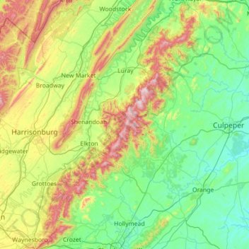
Nom : Carte topographique Shenandoah National Park, altitude, relief.
Altitude moyenne : 335 m
Altitude minimum : 72 m
Altitude maximum : 1.214 m
Faire un don
Équipez-vous pour votre prochaine aventure :
En tant que Partenaire Amazon, ce site perçoit une commission sur les achats éligibles sans surcoût pour vous.
Autres cartes topographiques
Cliquez sur une carte pour visualiser sa topographie, son altitude et son relief.
Faire un don
Équipez-vous pour votre prochaine aventure :
En tant que Partenaire Amazon, ce site perçoit une commission sur les achats éligibles sans surcoût pour vous.