Géolocaliser

Carte topographique Cessnock

Cliquez sur la carte pour afficher l’altitude.

À propos de cette carte

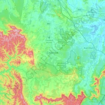
Nom : Carte topographique Cessnock, altitude, relief.

Lieu : Cessnock, New South Wales, Australia (-32.99167 151.19111 -32.67167 151.51111)

Altitude moyenne : 142 m

Altitude minimum : -1 m

Altitude maximum : 580 m

Autres cartes topographiques

Cliquez sur une carte pour visualiser sa topographie, son altitude et son relief.

Sydney

Australia > New South Wales

Sydney's topography is characterized by a diverse landscape that seamlessly blends coastal features with inland plateaus. The city is divided into two primary regions: the relatively flat Cumberland Plain to the south and west of Sydney Harbour, and the elevated Hornsby Plateau to the north. The Cumberland…

Altitude moyenne : 53 m

Newcastle

Australia > New South Wales

Altitude moyenne : 5 m

Tarana

Australia > New South Wales

Altitude moyenne : 920 m

Colo Heights

Australia > New South Wales

Altitude moyenne : 278 m

Cooranbong

Australia > New South Wales

Altitude moyenne : 72 m

Eden

Australia > New South Wales

Altitude moyenne : 55 m

Dirty Creek

Australia > New South Wales

Altitude moyenne : 77 m

Lismore

Australia > New South Wales

Altitude moyenne : 23 m

Mebbin

Australia > New South Wales

Altitude moyenne : 400 m

Pimlico

Australia > New South Wales

Altitude moyenne : 34 m

New Italy

Australia > New South Wales

Altitude moyenne : 34 m

Blueys Beach

Australia > New South Wales

Altitude moyenne : 33 m

Cowan

Australia > New South Wales

Altitude moyenne : 90 m

Bowral

Australia > New South Wales

Altitude moyenne : 690 m

Byron Bay

Australia > New South Wales

Byron Bay, located in northeastern New South Wales, Australia, is characterized by diverse topography shaped by its geological history. The town is part of the erosion caldera of the ancient Tweed Volcano, which erupted approximately 23 million years ago, resulting in the rich volcanic soils that define the…

Altitude moyenne : 7 m

Wingham

Australia > New South Wales

Altitude moyenne : 47 m

Snowball

Australia > New South Wales

Altitude moyenne : 1.001 m

Goulburn

Australia > New South Wales

Owing to its elevation, Goulburn has an oceanic climate (Cfb) with warm summers and cool winters; with a high diurnal range. Its climate is variable much of the year, though generally dry with maximum temperatures ranging from 11.8 °C (53.2 °F) in July to 28.3 °C (82.9 °F) in January. Rainfall is…

Altitude moyenne : 666 m

Putney

Australia > New South Wales

Altitude moyenne : 18 m

Burringbar

Australia > New South Wales

Altitude moyenne : 81 m

Wagga Wagga

Australia > New South Wales

Altitude moyenne : 183 m

Lane Cove North

Australia > New South Wales > Sydney

Altitude moyenne : 54 m

Blue Mountains

Australia > New South Wales

A sandstone plateau dominated by a landscape of endless eucalyptus forests, the Blue Mountains are located at the top of a 470-million-year-old quartzite. In the Permian period, a shallow sea covered the region, when rivers brought shales, siltstones and mudstones. Then during the Mesozoic period, rivers…

Altitude moyenne : 566 m

Nerrigundah

Australia > New South Wales

Altitude moyenne : 189 m

Central Coast Council

Australia > New South Wales

Altitude moyenne : 103 m

Junee Shire Council

Australia > New South Wales

Altitude moyenne : 328 m

North Parramatta

Australia > New South Wales > Sydney

Altitude moyenne : 42 m

Mollymook

Australia > New South Wales

Altitude moyenne : 24 m

Chatswood

Australia > New South Wales

Altitude moyenne : 81 m

Blackheath

Australia > New South Wales

Blackheath (postcode: 2785) is an Australian town located near the highest point of the Blue Mountains, between Katoomba and Mount Victoria in New South Wales. The town's altitude is about 1,065 metres (3,494 ft) AHD  and it is located about 120 kilometres (75 mi) west north-west of Sydney, 11 kilometres…

Altitude moyenne : 893 m

Camden Council

Australia > New South Wales

Altitude moyenne : 90 m

Umina Beach

Australia > New South Wales

Altitude moyenne : 38 m

Perisher Valley

Australia > New South Wales

Altitude moyenne : 1.704 m

Nimbin

Australia > New South Wales

Altitude moyenne : 235 m

Bingara

Australia > New South Wales

Altitude moyenne : 394 m

Illawarra

Australia > New South Wales

Altitude moyenne : 234 m

Braidwood

Australia > New South Wales

Altitude moyenne : 674 m

Castle Hill

Australia > New South Wales > Sydney

Altitude moyenne : 123 m

Cromer

Australia > New South Wales

Altitude moyenne : 46 m

Portland

Australia > New South Wales

At an altitude of 925 metres above sea level, Portland is the 21st highest town in Australia and classified as a temperate zone. Cool winters and warm summers ensure four distinct seasons and snowfalls each winter.

Altitude moyenne : 972 m

Jindabyne

Australia > New South Wales

Altitude moyenne : 1.077 m

Tenterfield

Australia > New South Wales

Altitude moyenne : 891 m

Nobbys Creek

Australia > New South Wales

Altitude moyenne : 66 m

Dalgety

Australia > New South Wales

Altitude moyenne : 866 m

Perthville

Australia > New South Wales

Altitude moyenne : 733 m

Alison

Australia > New South Wales

Altitude moyenne : 93 m

Congarinni

Australia > New South Wales

Altitude moyenne : 34 m

Old Grevillia

Australia > New South Wales

Altitude moyenne : 189 m

Mount Victoria

Australia > New South Wales

Mount Victoria (postcode: 2786) is a small township in the Blue Mountains of New South Wales, Australia. Mount Victoria is geographically the western most village and suburb of Greater Sydney on the great western highway in the City of Blue Mountains, located about 120 kilometres (75 mi) west-northwest by road…

Altitude moyenne : 901 m

Parramatta

Australia > New South Wales

Altitude moyenne : 22 m

Barrington Tops

Australia > New South Wales

Altitude moyenne : 1.107 m

Penrith

Australia > New South Wales > Sydney > Penrith

Penrith is a city in New South Wales, Australia, located in Greater Western Sydney, 55 kilometres (31 mi) west of the Sydney central business district on the banks of the Nepean River, on the outskirts of the Cumberland Plain. Its elevation is 32 metres (105 ft).

Altitude moyenne : 34 m

Campbelltown

Australia > New South Wales

Altitude moyenne : 96 m

Singleton Council

Australia > New South Wales

Altitude moyenne : 238 m

Tahmoor

Australia > New South Wales

Altitude moyenne : 269 m

Katoomba

Australia > New South Wales

Altitude moyenne : 904 m

Port Macquarie

Australia > New South Wales

Altitude moyenne : 5 m

Terrigal

Australia > New South Wales

Altitude moyenne : 13 m

Glen Innes

Australia > New South Wales

Altitude moyenne : 1.083 m

Kulnura

Australia > New South Wales

Altitude moyenne : 203 m

Tyalgum

Australia > New South Wales

Altitude moyenne : 161 m

Balgowlah

Australia > New South Wales > Sydney

Altitude moyenne : 40 m

Wauchope

Australia > New South Wales

Altitude moyenne : 32 m

Crookwell

Australia > New South Wales

Crookwell is a small town located in the Southern Tablelands of New South Wales, Australia, in the Upper Lachlan Shire. At the 2016 census, Crookwell had a population of 2,641. The town is at a relatively high altitude of 887 metres and there are several snowfalls during the winter months. The nearest major…

Altitude moyenne : 904 m

West Pennant Hills

Australia > New South Wales

Altitude moyenne : 130 m

Molong

Australia > New South Wales

Altitude moyenne : 595 m

Hay

Australia > New South Wales > Hay Shire Council

Altitude moyenne : 90 m

Jindera

Australia > New South Wales

Altitude moyenne : 272 m

Caffreys Flat

Australia > New South Wales

Altitude moyenne : 250 m

Thredbo

Australia > New South Wales

Altitude moyenne : 1.780 m

Tirrannaville

Australia > New South Wales

Altitude moyenne : 698 m

Bexhill

Australia > New South Wales

Altitude moyenne : 34 m

Waverton

Australia > New South Wales > Sydney

Altitude moyenne : 33 m

St Leonards

Australia > New South Wales > Sydney

Altitude moyenne : 69 m

Darlinghurst

Australia > New South Wales > Sydney

Altitude moyenne : 38 m

Armidale

Australia > New South Wales

Altitude moyenne : 1.036 m

Yass

Australia > New South Wales

Yass is located 280 km south-west of Sydney, on the Hume Highway. The Yass River, which is a tributary of the Murrumbidgee River, flows through the town. Yass is 59 km from Canberra; lying at an elevation of 505 m AMSL.

Altitude moyenne : 533 m

Greystanes

Australia > New South Wales > Sydney

Altitude moyenne : 53 m

Port Kembla

Australia > New South Wales

Altitude moyenne : 10 m

St Ives

Australia > New South Wales

Altitude moyenne : 125 m

Norah Head

Australia > New South Wales

Altitude moyenne : 9 m

Manly Vale

Australia > New South Wales > Sydney

Altitude moyenne : 34 m

Robertson

Australia > New South Wales

Altitude moyenne : 545 m

Mudgee

Australia > New South Wales

Altitude moyenne : 535 m

Équipez-vous pour votre prochaine aventure :

🍳Popotes de Randonnée - Ustensiles légers pour cuisiner en plein air
🧊Sacs Glacières - Gardez vos aliments frais au pied des sentiers
🛠️Outils Multifonctions - Le couteau suisse indispensable à l'explorateur
🔋Batteries solaires - Recharge d'appareils en pleine nature
🥾Chaussures de randonnée - Chaussures robustes et confortables pour randonnées sur tous types de terrains

En tant que Partenaire Amazon, ce site perçoit une commission sur les achats éligibles sans surcoût pour vous.