
Carte topographique Fenstanton
Cliquez sur la carte pour afficher l’altitude.
À propos de cette carte
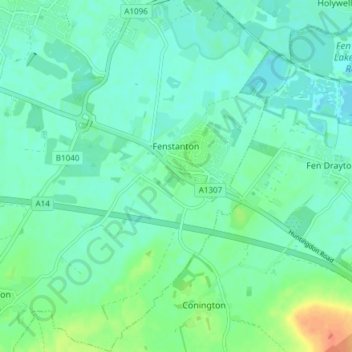
Nom : Carte topographique Fenstanton, altitude, relief.
Altitude moyenne : 11 m
Altitude minimum : 1 m
Altitude maximum : 39 m
Autres cartes topographiques
Cliquez sur une carte pour visualiser sa topographie, son altitude et son relief.
Green End
United Kingdom > England > Cambridgeshire > Huntingdonshire > Great Stukeley
Altitude moyenne : 32 m
Hinchingbrooke Country Park
United Kingdom > England > Cambridgeshire > Huntingdonshire > Huntingdon > Brampton
Altitude moyenne : 16 m
Huntingdon Castle
United Kingdom > England > Cambridgeshire > Huntingdonshire > Huntingdon > Hartford
Altitude moyenne : 14 m
Washingley
United Kingdom > England > Cambridgeshire > Huntingdonshire > Folksworth
Altitude moyenne : 48 m
Holywell
United Kingdom > England > Cambridgeshire > Huntingdonshire > Holywell
Altitude moyenne : 7 m
Hartford Marina
United Kingdom > England > Cambridgeshire > Huntingdonshire > Wyton
Altitude moyenne : 14 m
Leighton Bromswold
United Kingdom > England > Cambridgeshire > Huntingdonshire
Altitude moyenne : 49 m
Mill Pool
United Kingdom > England > Cambridgeshire > Huntingdonshire > Huntingdon
Altitude moyenne : 14 m