
Faire un don
Équipez-vous pour votre prochaine aventure :
En tant que Partenaire Amazon, ce site perçoit une commission sur les achats éligibles sans surcoût pour vous.
Carte topographique Windesheim
Cliquez sur la carte pour afficher l’altitude.
Faire un don
Équipez-vous pour votre prochaine aventure :
En tant que Partenaire Amazon, ce site perçoit une commission sur les achats éligibles sans surcoût pour vous.
À propos de cette carte
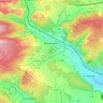
Nom : Carte topographique Windesheim, altitude, relief.
Altitude moyenne : 219 m
Altitude minimum : 134 m
Altitude maximum : 329 m
Faire un don
Équipez-vous pour votre prochaine aventure :
En tant que Partenaire Amazon, ce site perçoit une commission sur les achats éligibles sans surcoût pour vous.
Autres cartes topographiques
Cliquez sur une carte pour visualiser sa topographie, son altitude et son relief.
Pferdsfeld (Wüstung)
Deutschland > Rheinland-Pfalz > Landkreis Bad Kreuznach > Bad Sobernheim
Altitude moyenne : 376 m
Gräfenbacher Hütte
Deutschland > Rheinland-Pfalz > Landkreis Bad Kreuznach > Spabrücken
Altitude moyenne : 466 m
Ebernburg
Deutschland > Rheinland-Pfalz > Landkreis Bad Kreuznach > Bad Kreuznach
Die Ebernburg steht am südöstlichen Gemarkungsrand des gleichnamigen Stadtteils auf einem Bergsporn oberhalb des Nahetals in einer Höhe von 185 m ü. NHN.
Altitude moyenne : 189 m
Ellerspring
Deutschland > Rheinland-Pfalz > Landkreis Bad Kreuznach > Winterbach
Die Ellerspring liegt im Nordwesten des Landkreises Bad Kreuznach etwa im Zentrum des Naturparks Soonwald-Nahe. Er erhebt sich in der Gemarkung der Ortsgemeinde Winterbach, deren Dorfkirche rund 4,6 km südsüdöstlich vom Berggipfel steht. Etwa 1 km nordwestlich des Gipfels liegt im Tal des anfangs nach…
Altitude moyenne : 574 m
Faire un don
Équipez-vous pour votre prochaine aventure :
En tant que Partenaire Amazon, ce site perçoit une commission sur les achats éligibles sans surcoût pour vous.
"Schöner Berg"
Deutschland > Rheinland-Pfalz > Landkreis Bad Kreuznach > Schöneberg
Altitude moyenne : 352 m
Bosenberg
Deutschland > Rheinland-Pfalz > Landkreis Bad Kreuznach > Pfaffen-Schwabenheim
Altitude moyenne : 135 m
Faire un don
Équipez-vous pour votre prochaine aventure :
En tant que Partenaire Amazon, ce site perçoit une commission sur les achats éligibles sans surcoût pour vous.
Kalkbruchsee Hunsfels
Deutschland > Rheinland-Pfalz > Landkreis Bad Kreuznach > Stromberg
Altitude moyenne : 309 m
Mühlenteich
Deutschland > Rheinland-Pfalz > Landkreis Bad Kreuznach > Bad Kreuznach
Altitude moyenne : 140 m
Obere Horbachsmühle
Deutschland > Rheinland-Pfalz > Landkreis Bad Kreuznach > Heimweiler
Altitude moyenne : 319 m
Meckenbacher Höhe
Deutschland > Rheinland-Pfalz > Landkreis Bad Kreuznach > Merxheim
Altitude moyenne : 380 m
Faire un don
Équipez-vous pour votre prochaine aventure :
En tant que Partenaire Amazon, ce site perçoit une commission sur les achats éligibles sans surcoût pour vous.
Rüdesheim (Nahe)
Deutschland > Rheinland-Pfalz > Landkreis Bad Kreuznach > Rüdesheim
Altitude moyenne : 177 m
Montforterhof
Deutschland > Rheinland-Pfalz > Landkreis Bad Kreuznach > Duchroth > Montforterhof
Altitude moyenne : 289 m
Weiler bei Monzingen
Deutschland > Rheinland-Pfalz > Landkreis Bad Kreuznach > Weiler bei Monzingen > Weiler bei Monzingen
Altitude moyenne : 256 m
Hochstädten
Deutschland > Rheinland-Pfalz > Landkreis Bad Kreuznach > Hochstädten
Altitude moyenne : 272 m
Faire un don
Équipez-vous pour votre prochaine aventure :
En tant que Partenaire Amazon, ce site perçoit une commission sur les achats éligibles sans surcoût pour vous.