
Carte topographique Minot
Carte interactive
Cliquez sur la carte pour afficher l’altitude.
À propos de cette carte
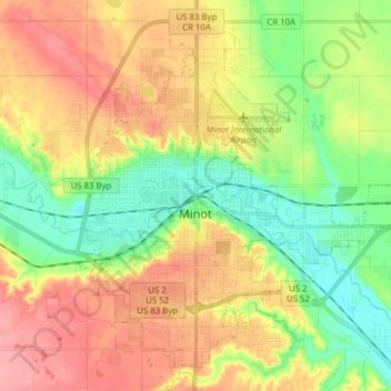
Nom : Carte topographique Minot, altitude, relief.
Lieu : Minot, Ward County, North Dakota, United States (48.19164 -101.34295 48.28304 -101.18767)
Altitude moyenne : 510 m
Altitude minimum : 467 m
Altitude maximum : 558 m
The elevation of the river at the city center is 1,540 feet (470 m) above sea level. The valley sits 160 feet (49 m) below the surrounding plains; the elevation at the Minot International Airport on North Hill is 1,716 feet (523 m). The city has several small horseshoe-shaped oxbow lakes within its limits near the river, created by the Mouse's meandering course.