
Faire un don
Équipez-vous pour votre prochaine aventure :
En tant que Partenaire Amazon, ce site perçoit une commission sur les achats éligibles sans surcoût pour vous.
Carte topographique Harris Mountains
Cliquez sur la carte pour afficher l’altitude.
Faire un don
Équipez-vous pour votre prochaine aventure :
En tant que Partenaire Amazon, ce site perçoit une commission sur les achats éligibles sans surcoût pour vous.
À propos de cette carte
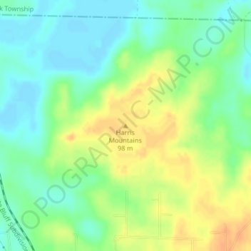
Nom : Carte topographique Harris Mountains, altitude, relief.
Altitude moyenne : 82 m
Altitude minimum : 67 m
Altitude maximum : 100 m
Faire un don
Équipez-vous pour votre prochaine aventure :
En tant que Partenaire Amazon, ce site perçoit une commission sur les achats éligibles sans surcoût pour vous.
Autres cartes topographiques
Cliquez sur une carte pour visualiser sa topographie, son altitude et son relief.
Pine Bluff
United States > Arkansas > Jefferson County
The city is situated in the Southeast section of the Arkansas Delta and straddles the Arkansas Timberlands region to its west. Its topography is flat with wide expanses of farmland, similar to other places in the Delta Lowlands. Pine Bluff has numerous creeks, streams, and bayous, including Bayou Bartholomew,…
Altitude moyenne : 69 m
Faire un don
Équipez-vous pour votre prochaine aventure :
En tant que Partenaire Amazon, ce site perçoit une commission sur les achats éligibles sans surcoût pour vous.