
Faire un don
Équipez-vous pour votre prochaine aventure :
En tant que Partenaire Amazon, ce site perçoit une commission sur les achats éligibles sans surcoût pour vous.
Carte topographique Hillsborough
Cliquez sur la carte pour afficher l’altitude.
Faire un don
Équipez-vous pour votre prochaine aventure :
En tant que Partenaire Amazon, ce site perçoit une commission sur les achats éligibles sans surcoût pour vous.
Hillsborough
According to the United States Census Bureau, the town has a total area of 6.2 square miles (16 km2), all of it land. The area's considerably winding, hilly topography, and impossibility of a grid layout make Hillsborough notoriously challenging to navigate. Many lots include fairly steep slopes, particularly the western side of the town, with the landscape generally flattening to the east as it descends from the 280 freeway to El Camino Real and the towns of Burlingame and San Mateo.
Faire un don
Équipez-vous pour votre prochaine aventure :
En tant que Partenaire Amazon, ce site perçoit une commission sur les achats éligibles sans surcoût pour vous.
À propos de cette carte
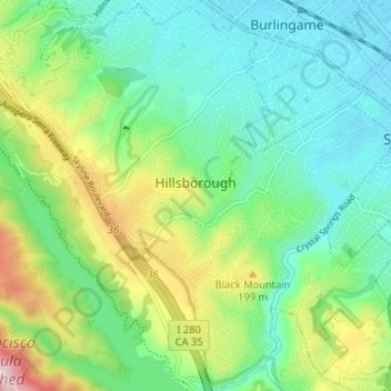
Nom : Carte topographique Hillsborough, altitude, relief.
Lieu : Hillsborough, San Mateo County, California, United States (37.53005 -122.39343 37.58085 -122.32838)
Altitude moyenne : 100 m
Altitude minimum : 3 m
Altitude maximum : 331 m
Faire un don
Équipez-vous pour votre prochaine aventure :
En tant que Partenaire Amazon, ce site perçoit une commission sur les achats éligibles sans surcoût pour vous.
Autres cartes topographiques
Cliquez sur une carte pour visualiser sa topographie, son altitude et son relief.
San Carlos
United States > California > San Mateo County > San Carlos > San Carlos
Altitude moyenne : 47 m