
Carte topographique Georgia
Carte interactive
Cliquez sur la carte pour afficher l’altitude.
À propos de cette carte
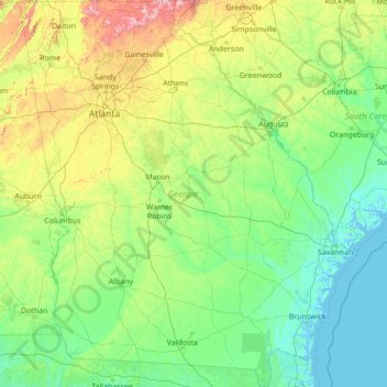
Nom : Carte topographique Georgia, altitude, relief.
Lieu : Georgia, United States of America (30.35576 -85.60524 35.00136 -80.75143)
Altitude moyenne : 136 m
Altitude minimum : -3 m
Altitude maximum : 1.368 m
The majority of the state is primarily a humid subtropical climate. Hot and humid summers are typical, except at the highest elevations. The entire state, including the North Georgia mountains, receives moderate to heavy precipitation, which varies from 45 inches (1143 mm) in central Georgia to approximately 75 inches (1905 mm) around the northeast part of the state. The degree to which the weather of a certain region of Georgia is subtropical depends on the latitude, its proximity to the Atlantic Ocean or Gulf of Mexico, and the elevation. The latter factor is felt chiefly in the mountainous areas of the northern part of the state, which are farther away from the ocean and can be 4500 feet (1350 m) above sea level. The USDA plant hardiness zones for Georgia range from zone 6b (no colder than −5 °F (−21 °C) ) in the Blue Ridge Mountains to zone 8b (no colder than 15 °F (−9 °C) ) along the Atlantic coast and Florida border.
Autres cartes topographiques
Cliquez sur une carte pour visualiser sa topographie, son altitude et son relief.
drainage
United States of America > Georgia
drainage, Dougherty County, Georgia, 31721, United States of America
Altitude moyenne : 64 m
Midway
United States of America > Georgia > Midway
Midway, Habersham County, Georgia, United States of America
Altitude moyenne : 438 m
Clarkston
United States of America > Georgia > Clarkston
Clarkston, DeKalb County, Georgia, 30021, United States of America
Altitude moyenne : 307 m
Warner Robins
United States of America > Georgia > Warner Robins
Warner Robins, Houston County, Georgia, United States of America
Altitude moyenne : 101 m
Nahunta
United States of America > Georgia > Nahunta
Nahunta, Brantley County, Georgia, 31553, United States of America
Altitude moyenne : 19 m
Saint Clair Estates
United States of America > Georgia > Saint Clair Estates
Saint Clair Estates, Glynn County, Georgia, 31522, United States of America
Altitude moyenne : 4 m
Charlton County
United States of America > Georgia
Charlton County, Georgia, United States of America
Altitude moyenne : 27 m
Leveretts
United States of America > Georgia > Leveretts
Leveretts, Webster County, Georgia, 31777, United States of America
Altitude moyenne : 143 m
Hillcrest
United States of America > Georgia > Hillcrest
Hillcrest, Oconee County, Georgia, 30677, United States of America
Altitude moyenne : 231 m
Edge Hill
United States of America > Georgia > Edge Hill
Edge Hill, Glascock County, Georgia, United States of America
Altitude moyenne : 136 m
Saint George
United States of America > Georgia > Saint George
Saint George, Georgia, United States of America
Altitude moyenne : 21 m
Hickox
United States of America > Georgia > Hickox
Hickox, Brantley County, Georgia, United States of America
Altitude moyenne : 18 m
Okefenokee National Wildlife Refuge
United States of America > Georgia
Okefenokee National Wildlife Refuge, Georgia, United States of America
Altitude moyenne : 35 m
Folkston
United States of America > Georgia > Folkston
Folkston, Charlton County, Georgia, 31537, United States of America
Altitude moyenne : 24 m
Vine City
United States of America > Georgia > Atlanta > Vine City
Vine City, Atlanta, Fulton County, Georgia, 30313, United States of America
Altitude moyenne : 301 m
Edmunston Creek
United States of America > Georgia
Edmunston Creek, Lumpkin County, Georgia, United States of America
Altitude moyenne : 490 m
Burke County
United States of America > Georgia
Burke County, Georgia, United States of America
Altitude moyenne : 75 m