Géolocaliser
👉 Easily get elevation data in JSON, GeoTIFF and KML formats using Elevation API
Merci de soutenir ce site ❤️
Faire un don

Équipez-vous pour votre prochaine aventure :

En tant que Partenaire Amazon, ce site perçoit une commission sur les achats éligibles sans surcoût pour vous.

Carte topographique Stanthorpe

Cliquez sur la carte pour afficher l’altitude.

Stanthorpe

Owing to its elevation, Stanthorpe features a subtropical highland climate. At an altitude of 811 metres (2,661 ft), Stanthorpe holds the record for the lowest temperature recorded in Queensland at −10.6 °C (12.9 °F) on 23 June 1961. Sleet and light snowfalls are occasionally recorded, with the most significant snowfall in over 30 years occurring on 17 July 2015.

À propos de cette carte

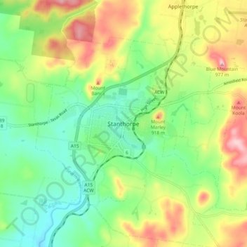
Nom : Carte topographique Stanthorpe, altitude, relief.

Lieu : Stanthorpe, Southern Downs Regional, Queensland, 4380, Australia (-28.69599 151.89383 -28.61599 151.97383)

Altitude moyenne : 840 m

Altitude minimum : 760 m

Altitude maximum : 966 m

Équipez-vous pour votre prochaine aventure :

🪑Chaises Pliantes - Reposez-vous confortablement n'importe où
🎒Sacs à dos de trekking - Sacs à grande capacité pour randonnées longues
SpraSprays Imperméabilisants - Redonnez de l'étanchéité à vos vêtements techniques
🧤Gants de randonnée - Gants légers ou thermiques pour outdoor
📖Livres Géo Junior - Apprendre à lire une carte en s'amusant

En tant que Partenaire Amazon, ce site perçoit une commission sur les achats éligibles sans surcoût pour vous.