
Carte topographique Salen
Carte interactive
Cliquez sur la carte pour afficher l’altitude.
À propos de cette carte
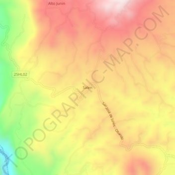
Nom : Carte topographique Salen, altitude, relief.
Lieu : Salen, Isnos, Sur, Huila, RAP (Especial) Central, Colombia (1.92170 -76.28026 1.96170 -76.24026)
Altitude moyenne : 1.811 m
Altitude minimum : 1.392 m
Altitude maximum : 2.104 m
Autres cartes topographiques
Cliquez sur une carte pour visualiser sa topographie, son altitude et son relief.
Isnos Huila
Isnos Huila, Isnos, Sur, Huila, RAP (Especial) Central, Colombia
Altitude moyenne : 1.782 m
La Muralla
La Muralla, Isnos, Sur, Huila, RAP (Especial) Central, Colombia
Altitude moyenne : 1.714 m
El Mortiño
El Mortiño, Isnos, Sur, Huila, RAP (Especial) Central, 418060, Colombia
Altitude moyenne : 1.591 m
Parque Nacional Natural Puracé
Parque Nacional Natural Puracé, Isnos, Sur, Huila, RAP (Especial) Central, Colombia
Altitude moyenne : 2.708 m
Paloquemao
Paloquemao, Isnos, Sur, Huila, RAP (Especial) Central, Colombia
Altitude moyenne : 2.152 m