
Faire un don
Équipez-vous pour votre prochaine aventure :
En tant que Partenaire Amazon, ce site perçoit une commission sur les achats éligibles sans surcoût pour vous.
Carte topographique Cloudcroft
Cliquez sur la carte pour afficher l’altitude.
Faire un don
Équipez-vous pour votre prochaine aventure :
En tant que Partenaire Amazon, ce site perçoit une commission sur les achats éligibles sans surcoût pour vous.
Cloudcroft
Cloudcroft is a village in Otero County, New Mexico, United States, and is located within the Lincoln National Forest. The population was 674 at the 2010 census. Despite being located in an otherwise arid region, its high elevation (8,676 feet (2,644 m); one of the highest in the U.S.) allows for a mild summer that makes it a popular tourist attraction in west Texas and southern New Mexico. It was named by Fodor's in 2002 as the Number 3 "Most Overlooked and Underrated Destination Spot." Tourism remains the primary economic driver of the village.
Faire un don
Équipez-vous pour votre prochaine aventure :
En tant que Partenaire Amazon, ce site perçoit une commission sur les achats éligibles sans surcoût pour vous.
À propos de cette carte
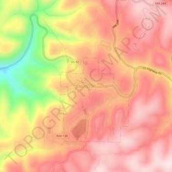
Nom : Carte topographique Cloudcroft, altitude, relief.
Lieu : Cloudcroft, Otero County, New Mexico, 88317, United States (32.93766 -105.76272 32.97766 -105.72272)
Altitude moyenne : 2.636 m
Altitude minimum : 2.352 m
Altitude maximum : 2.776 m
Faire un don
Équipez-vous pour votre prochaine aventure :
En tant que Partenaire Amazon, ce site perçoit une commission sur les achats éligibles sans surcoût pour vous.