Géolocaliser
👉 Easily get elevation data in JSON, GeoTIFF and KML formats using Elevation API
Merci de soutenir ce site ❤️
Faire un don

Carte topographique Jhargram

Cliquez sur la carte pour afficher l’altitude.

👉 Easily get elevation data in JSON, GeoTIFF and KML formats using Elevation API
Merci de soutenir ce site ❤️
Faire un don

Jhargram

Jhargram is located at 22°27′N 86°59′E / 22.45°N 86.98°E / 22.45; 86.98. It has an average elevation of 81 metres (265 feet). The weather, like much of Bengal, is extremely humid and tropical. Temperatures can reach as high as 46 °C in the hot and dry months of May and June but can plummet to 4 °C in the chilly nights of December and January.

Wikipedia (CC-BY-SA 3.0)

À propos de cette carte

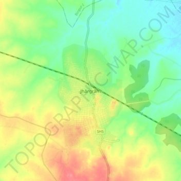
Nom : Carte topographique Jhargram, altitude, relief.

Lieu : Jhargram, West Bengal, 721507, India (22.41385 86.95495 22.49385 87.03495)

Altitude moyenne : 79 m

Altitude minimum : 51 m

Altitude maximum : 116 m

Équipez-vous pour votre prochaine aventure :

🧤Gants Thermiques Tactiles - Manipulez votre écran sans avoir froid aux mains
👟Semelles de Confort - Réduisez la fatigue lors des marches sur bitume
🧢Chapeaux de randonnée - Protection solaire maximale
🗺️Cartes du monde murales - Décoration et géographie
🧥Ponchos de Pluie - Protection rapide et totale pour randonneur et sac

En tant que Partenaire Amazon, ce site perçoit une commission sur les achats éligibles sans surcoût pour vous.