
Carte topographique Beckington
Cliquez sur la carte pour afficher l’altitude.
À propos de cette carte
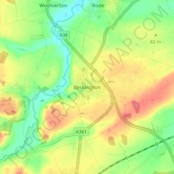
Nom : Carte topographique Beckington, altitude, relief.
Lieu : Beckington, Somerset, England, BA11 6SX, United Kingdom (51.24570 -2.30590 51.28570 -2.26590)
Altitude moyenne : 74 m
Altitude minimum : 41 m
Altitude maximum : 110 m
Autres cartes topographiques
Cliquez sur une carte pour visualiser sa topographie, son altitude et son relief.
Quantock Hills National Landscape
United Kingdom > England > Somerset > Over Stowey
Altitude moyenne : 116 m
Mells Park
United Kingdom > England > Somerset > Vobster
The architect Edwin Lutyens had known the Horners, and Mells Park, since 1896. In 1918 he unsuccessfully tried to persuade the Horners to rebuild Park House. However, Reginald McKenna, the chairman of Midland Bank, and formerly Home Secretary and Chancellor of the Exchequer under Asquith, was married to Pamela…
Altitude moyenne : 134 m
Priddy
United Kingdom > England > Somerset
The village lies in a small hollow near the summit of the Mendip range of hills, at an elevation of nearly 1,000 feet (300 m) above sea-level, and has evidence of occupation since neolithic times. There are remains of lead mining activities and caves in the limestone beneath the village.
Altitude moyenne : 206 m
Muchelney
United Kingdom > England > Somerset
Muchelney (/ˈmʌtʃəlni/) is a clustered village and civil parish in Somerset, England, extending for 3 kilometres (1.9 mi) from the south bank of the River Parrett and that has a clustered centre. This is 1 mile (1.6 km) south of Huish and Langport and 4 miles (6.4 km) south west of Somerton in the South…
Altitude moyenne : 9 m