
Faire un don
Équipez-vous pour votre prochaine aventure :
En tant que Partenaire Amazon, ce site perçoit une commission sur les achats éligibles sans surcoût pour vous.
Carte topographique Mount Major
Cliquez sur la carte pour afficher l’altitude.
Faire un don
Équipez-vous pour votre prochaine aventure :
En tant que Partenaire Amazon, ce site perçoit une commission sur les achats éligibles sans surcoût pour vous.
À propos de cette carte
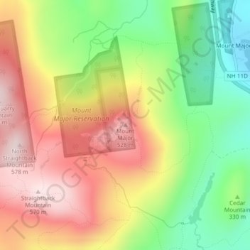
Nom : Carte topographique Mount Major, altitude, relief.
Altitude moyenne : 364 m
Altitude minimum : 153 m
Altitude maximum : 573 m
Faire un don
Équipez-vous pour votre prochaine aventure :
En tant que Partenaire Amazon, ce site perçoit une commission sur les achats éligibles sans surcoût pour vous.
Autres cartes topographiques
Cliquez sur une carte pour visualiser sa topographie, son altitude et son relief.
Rattlesnake Island
United States > New Hampshire > Belknap County > Alton
Rattlesnake Island is about 2 miles (3 km) long, and approximately 5 miles (8 km) around its shore. The topography varies greatly. Some sections of the island are quite steep, with the land rising steeply from the shore (affording views of the area), while other sections, particularly on the "peninsula", which…
Altitude moyenne : 159 m
Sleepers Island
United States > New Hampshire > Belknap County > Alton > Smith Point
Altitude moyenne : 163 m
Faire un don
Équipez-vous pour votre prochaine aventure :
En tant que Partenaire Amazon, ce site perçoit une commission sur les achats éligibles sans surcoût pour vous.